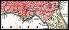
|
1850, Aus der Gravisanstalt des Bibliographischan Instituts zu.
Hillsburghaus Amsterdam Paris u. Philadelphia Map.  |
| 
|
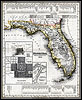
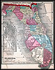
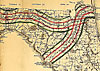
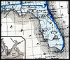
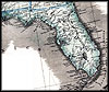
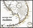
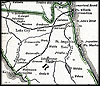
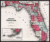
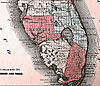
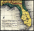
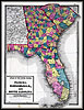
Map
of Florida from 1850. |
| 
|
1851,
A new map of the United States. Upon which are delineated its vast works
of internal communication, routes across the continent &c. Published
by Philadelphia, Lippincott, Grambo & Co. |
 |
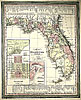
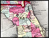
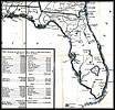
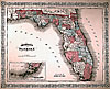
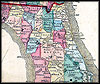
Township
map of Florida from 1856. |
|
1857, Gaston map. |
| 
|
1859,
Johnson's new railroad & county copper plate map of the southern states
from the latest and best information. |
| 
|
1859,
Johnson's new railroad & county copper plate map of the southern states
from the latest and best information. |
 |
1859,
Surveyor General map. |
 |
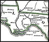
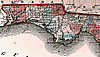
Detailed
view of the Florida panhandle from 1859. |
 |
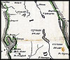
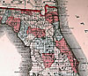
Detailed
view of the northeast counties of Florida from 1859. |
 |
Birds
eye view of Florida and part of Georgia and Alabama Drawn from nature
and lith, pubished by New York, John Bachmann, c1861. |
| 
|
1861,
Colton's United States shewing the military stations, forts &c. Entered
according to Act of Congress in the year 1855, by J.H. Colton. |
| 
|
1861,
Denoyer-Geppert Company map. |
| 
|
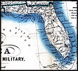
1861,
Military map of the United States & territories showing the location
of the military posts, arsenals, Navy Yards, & ports of entry. Published
by P.S. Duval & Son. |
| 
|
1861,
Thayer's statistical and military map of the middle and southern states.
|
| 
|
1861,
Thayer's statistical and military map of the middle and southern states.
|
| 
|
1861,
Thayer's statistical and military map of the middle and southern states.
|
| 
|
1861,
Wyld's military map of the United States, the northern states, and the
southern confederate states: with the forts, harbours, arsenals, and
military positions. |
| 
|
1862,
Colton's rail-road and military map of the United States, Mexico, the
West Indies, &c. |
| 
|
1862,
Perrine's New military map illustrating the seat of war : [southern
U.S.]. |
| 
|
1862,
Perrine's New military map illustrating the seat of war : [southern
U.S.]. |
| 
|
1862,
Perrine's New military map illustrating the seat of war : [southern
U.S.]. |
| 
|
1862,
The historical war map. Published by Buffalo, N.Y. E. R. Jewett & Co.,
engravers. |
| 
|
1862,
The historical war map. Published by Buffalo, N.Y. E. R. Jewett & Co.,
engravers. |
| 
|
1862,
The historical war map. Published by Buffalo, N.Y. E. R. Jewett & Co.,
engravers. |
| 
|
1862,
The historical war map. Published by Buffalo, N.Y. E. R. Jewett & Co.,
engravers. |
| 
|
1862,
The historical war map. Published by Buffalo, N.Y. E. R. Jewett & Co.,
engravers. |
| 
|
1862,
The historical war map. Published by Buffalo, N.Y. E. R. Jewett & Co.,
engravers. |
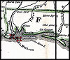
 |
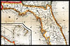
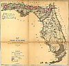
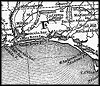
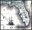
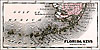
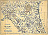
Railroad
and military map of Florida from 1862. |
|
1863, Johnson & Ward. |
 |
1863,
Map of Florida that was, "Entered according to Act of Congress in the
year 1863 by A. J. Johnson in the clerks office of the District Court
of the United States for the Southern District of New York." |
 |
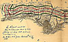
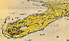
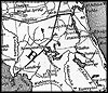
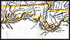
Detailed
view of the panhandle from an 1863 map of Florida. |
 |
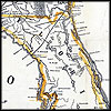
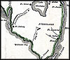
Detailed
view of north Florida from an 1863 map of Florida. |
 |
Detailed
view of south Florida from an 1863 map of Florida. |
 |
Detailed
view of the Florida Keys from an 1863 map of Florida. |
| 
|
1863,
Bacon's steel plate map of America, political, historical & military.
Published by London, Bacon & Co. |
| 
|
1863,
Lloyd's new county map of the United States and Canadas showing battle
fields, railroads, &c., compiled from the latest goverment surveys &
other reliable & official sources, drawn and engraved by Schonberg &
Co., New York. |
| 
|
1863,
Lloyd's new county map of the United States and Canadas showing battle
fields, railroads, &c., compiled from the latest goverment surveys &
other reliable & official sources, drawn and engraved by Schonberg &
Co., New York. |
 |
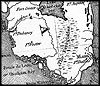
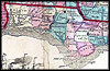
Map
of North Florida and South Georgia from 1864. |
| 
|
1864,
Historical sketch of the rebellion Drawn by H. Lindenkohl. Chas. G.
Krebs, lith. Published by Office of the U.S. Coast Survey. |
| 
|
1864,
Historical sketch of the rebellion Drawn by H. Lindenkohl. Chas. G.
Krebs, lith. Published by Office of the U.S. Coast Survey. |
| 
|
1865,
Lloyd's new military map of the border & southern states [Drawn by Edward
S. Hall. Waters & Sons, engravers]. |
| 
|
1865,
Lloyd's new military map of the border & southern states [Drawn by Edward
S. Hall. Waters & Sons, engravers]. |
|
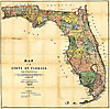
1873, Map of Florida. |