| Home > Maps > Seminole County | |
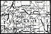
Click on a thumbnail image to view a full size version of that map.
Seminole County is Florida's 50th county, established on April 25, 1913, from a segment of Orange County. It gains its name from the Native Americans who refused to be assimilated into Spanish culture. The term is likely derived from the term cimarrones, and describes animals, plants, and human slaves who refuse domestication. Sanford is the county seat.
For earlier maps of this area, visit the Orange County map gallery.
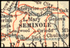
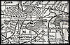
1914, Collier map.
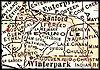
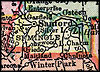
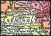
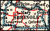
1916, The New Reference Atlas of the World, published by C. S. Hammond & Company.
| Home > Maps > Seminole County |
Exploring
Florida: A Social Studies Resource for Students and Teachers
Produced by the Florida Center for Instructional
Technology,
College of Education, University of South Florida © 2004.