| Home > Maps > Hurricanes > Route Maps by Decade | |
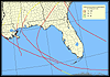
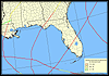
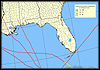
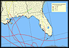
Click on a thumbnail photo to view a full size version of that map.
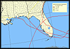
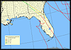
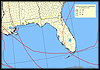
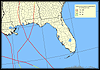
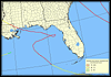
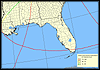
This map set contains tracks of major hurricanes that made landfall in the United States classified on the Saffir-Simpson Hurricane Scale as category 3 or higher hurricanes from 1851 through 2000, published by the U.S. Geological Survey. The storm tracks were created from observations of storm center locations taken every six hours.
* The Saffir-Simpson Hurricane Scale uses wind speed as the determining factor.
| Home > Maps > Hurricanes > Route Maps by Decade |
Exploring
Florida: A Social Studies Resource for Students and Teachers
Produced by the Florida Center for Instructional
Technology,
College of Education, University of South Florida © 2004.