| Home > Maps > USGS Map Key | |
USGS Map Key
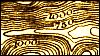
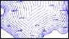
This key contains selected symbols used on United States Geological Survey Maps and on Florida Soil Maps based on USGS Maps. In general, relief features are printed in brown, water features are printed in blue, and cultural features are printed in black.
If you came to this page from an Exploring Florida map, this is a pop-up window. You can reposition this window to see both this key and your original map. When you are finished with this window, just close it to return to the map you were viewing.
Contours (Contours showing depth of water printed in blue)
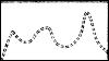
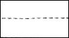
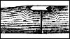
Depression contours
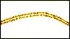
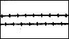
Levee
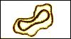
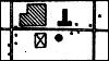
Mine dumps
Trailings or mining debris
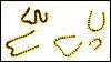
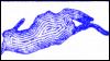
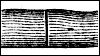
Sand and sand dunes
Streams
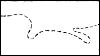
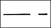
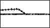
Falls and rapids
Intermittent streams and ditches
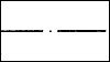
Canals or ditches
Unsurveyed stream and abandoned canal
Intermittent lake
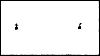
Spring, Well
Marsh
Submerged marsh
Lake or pond
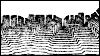
Roads and buildings
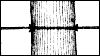
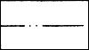
Good public road
Poor public or private road
Trail
Power transmission line
Wharves
Breakwater and jetties
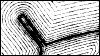
Bridge
Drawbridges
Ferry (point upstream)
Canal lock (point upstream)
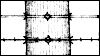
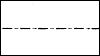
State line
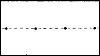
County line
Civil Township or district line
Reservation line
Land grant line
City, village, or borough line
Small park or cemetery line
Railroads
Electric railroad
Dam
Dam with lock
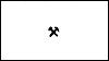
Mine or quarry
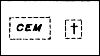
Cemeteries
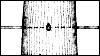
Church, School (distinguished on recent maps)
Lighthouse or beacon
| Home > Maps > USGS Map Key |
Exploring
Florida: A Social Studies Resource for Students and Teachers
Produced by the Florida Center for Instructional
Technology,
College of Education, University of South Florida © 2004.