|
Each panorama movie
is available in two file sizes. The small movies display at the same
size on your computer screen as the large movies, but the small movies
do not allow you to zoom in on as much detail as the large movies do.
Most of the color movies are a full circle (360 degrees). The black and white VRs are approximately 180 degree views.
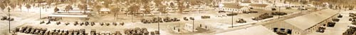
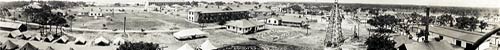
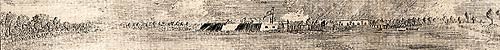
Camp Blanding,
1941

 140 K
140 K  674 K
674 K
An
aerial photo of Camp Blanding, 1941.
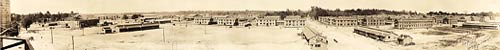
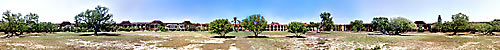
Camp Joseph
E. Johnston, 1918
125 K
493 K
An
aerial view of Camp Joseph E. Johnston, 1918.
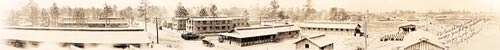
Camp Joseph
E. Johnston, 1918
112 K
534 K
An
aerial view of Camp Joseph E. Johnston, circa 1918.
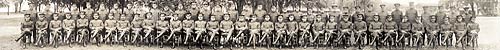
Officers at Camp Joseph E. Johnston, 1918
224 K
836 K
Officers
of the Quartermaster Corps Training and Mobilization Camp at Camp Joseph
E. Johnston, Jacksonville.
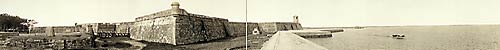
Castillo de San Marcos, 1910
88 K
332 K
A view
of the Castillo de San Marcos, circa 1910. The Castillo was known as
Fort Marion from 1825 until 1942.
Castillo de San Marcos, 1912
144 K
596 K
A view
of the Castillo de San Marcos, circa 1912. The Castillo was known as
Fort Marion from 1825 until 1942.
Castillo de San Marcos, 1912
112 K
432 K
A view
of the Castillo de San Marcos, circa 1912. The Castillo was known as
Fort Marion from 1825 until 1942.
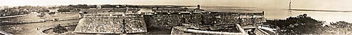
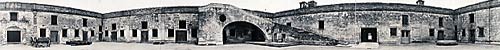
Castillo de San Marcos, 1912
92 K
360 K
A panorama
view of the courtyard, the Plaza de Armas, at the Castillo de San Marcos,
circa 1912. The panorama begins at the ramp built to pull cannons to
the top of the fort. To the right of the ramp is the "Sally Port," the
only entrance to the fort.
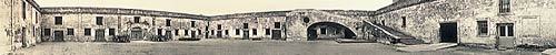
Castillo de San Marcos, 1912
164 K
688 K
A panorama
view of the courtyard, the Plaza de Armas, at the Castillo de San Marcos,
circa 1912. The panorama begins at the ramp built to pull cannons to
the top of the fort. To the right of the ramp is the "Sally Port," the
only entrance to the fort. At the extreme left is the entrance to the
Chapel of St. Mark.
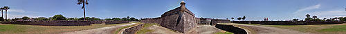
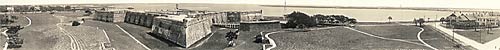
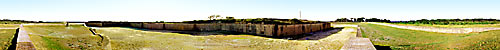
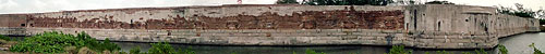
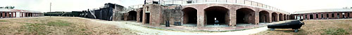
Castillo de San Marcos
580 K
1.0 MB
This
is a view of the San Pedro Bastion from the top of the moat. The moat
was usually kept dry and used as a pen for domestic animals.
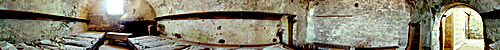
Castillo de San Marcos Guard Room
446 K
916 K
Soldiers
lived in town with their families, not inside the Castillo.
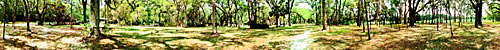
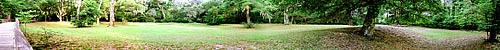
Dade Battlefield Historic State Park
812 K
2.6 MB
This
is the site of the December 28, 1835 ambush by Seminoles of an artillery
and infantry relief unit marching toward Fort King from Tampa.
Fort Barrancas,
1919
165 K
599 K
An
aerial of Fort Barrancas military camp, circa 1919.
Fort Clinch
248 K
932 K
Fort
Clinch was named for Gen. Duncan Lamont Clinch, an important figure
in Florida's Seminole War of the 1830s.
Fort Jefferson
295 K
1.39MB
Fort
Jefferson is located on Garden Key in the Dry Tortugas, about 70 miles
west of Key West. It was named in honor of our third president.
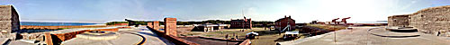
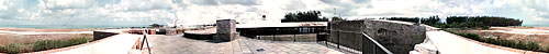
Fort Pickens
338 K
834 K
This
VR opens looking south along the counterscarp wall which protected the
landward face of the fort from artillery fire.
Fort St. Marks, 1781
312 K
1.10 MB
Detailed
view from a map published in 1781 of East and West Florida. The map
includes this small sketch of Fort St. Marks.
Olustee
Battlefield
752 K
1.5 MB
The
Battle of Olustee (or Ocean Pond) was fought on February 20, 1864.
Olustee
Battlefield
448 K
1.0 MB
The
Battle of Olustee (or Ocean Pond) was fought on February 20, 1864.
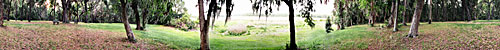
San Marcos de Apalachee
400 K
1.0 MB
This
VR begins looking west toward the Wakulla River. This was the site of
a number of early Spanish forts.
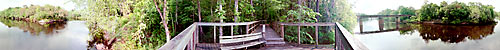
Suwannee River
320 K
1.0 MB
The
first view in this VR is of the wooden walk leading to an overlook.
Suwannee River Earthworks
516 K
1.2 MB
These
earthworks were built by Confederate troops during the Civil War to
protect the nearby bridge, which was a target of the Union Army.
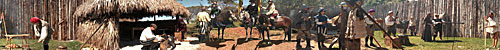
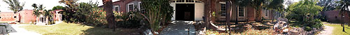
DeSoto Reenactment
512 K
1.1 MB
This
is a reenactment of a typical camp that DeSoto and his men would have
built.
Fort Taylor
248 K
1.5 MB
Fort
Zachary Taylor is located at the end of Southard street in Key West.
Named after U.S. President Zachary Taylor, the fort is a perfect example
of the wealth of history Florida has to offer.
Fort Taylor
208 K
1 MB
The
fort, located in Key West, was an important outpost during the Civil
War.
Fort Taylor
420 K
2.6 MB
Numerous
blockade-running ships were detained at Key West harbor and guarded
by Fort Taylor's cannons.
Fort Cooper State Park
368 K
808 K
This
park is named for Major Mark Anthony Cooper, commander of five companies
of the First Georgia Battalion of Volunteers during the Second Seminole
War.
East Martello
460 K
1.7 MB
Its
outer bulwark and inner citadel with eight-foot thick granite walls
built during the Civil War era were a monument to military engineering
and could have withstood any amount of bombardment at the time.

Brooksville Raid
708 K
1 MB
This
is annual reenactment of an 1864 raid by union troops in Hernando County.
|