| Home > Florida Then & Now > Supplemental Florida Reading Passages > Florida's Water Then and Now | |
Florida's Land Then and Now
The land we now call Florida began to form by a combination of volcanic activity and the deposit of marine sediments. It formed along northwest Africa about 530 million years ago.
In earliest times, Florida was part of Gondwanaland, the super continent that later divided into Africa and South America. There is evidence that Florida separated from Gondwanaland about 300 million years ago.
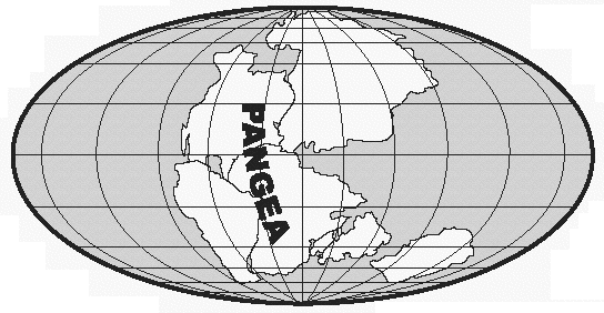
Florida eventually found itself wedged between Gondwanaland and North America when they combined to form the super continent Pangea. When Pangea began to break up, Florida remained behind with North America.
Florida slipped slowly beneath the waves to become part of North America’s continental shelf. The landmass that is now Florida remained shallowly submerged beneath the ocean. Coral, shellfish, and fish skeletons piled up. This created a layer of limestone hundreds (in some places thousands) of feet thick.
As the Appalachian Mountains eroded, sand and clay were deposited over Florida’s limestone layer. Much of the quartz sand covering the state today came from the rocks of that mountain chain.
Throughout most of its history, Florida has been under water. Portions of the Florida peninsula have been above or below sea level at least four times. As glaciers of ice in the north expanded and melted, the Florida peninsula emerged and submerged.
When the sea level was lowest, the land area of Florida was much larger than it is now. The sea level was as much as 100 feet lower than at present. Florida’s west coastline was probably 100 miles further out. As the climate warmed, the glaciers melted. This raised the sea level and flooded the Florida peninsula. The sea level stood at least 100 to 150 feet above the present level. Florida probably consisted of islands.
The formation of the Florida Keys occurred when tiny coral created a 150-mile long chain of underwater coral reefs. As the landmass of southern Florida began its slow rise, the reefs also began to emerge.
The Florida peninsula is the emergent portion of the Florida Platform. This is a wide, relatively flat land formation. The Florida Platform lies between the deep waters of the Gulf of Mexico and the Atlantic Ocean. Florida's landscape varies widely. Many of Florida’s prominent features have resulted from karst, a landscape with a base layer of limestone. Because limestone is porous, freshwater gradually dissolves the rock and forms cracks and passages.
The limestone layer of the state is honeycombed with underground rivers. Where the rivers break through to the surface, springs and sinkholes are found. Lakes and wetlands are abundant.
Although Florida is relatively flat, there are different elevations. They range from 0 to 320 feet above sea level. The highest elevations in the state are in the central highlands, which run down the center of the state.
Florida is classified as a stable geological area. This means that although some areas may experience tremors, severe weather events (such as hurricanes and tornadoes) pose tremendously greater threats to Florida than do earthquakes.
Flood prone areas in Florida are in either low-lying coastal areas or near inland rivers and lakes. Severe flooding problems can result from the storm surge developed as hurricanes approach the shoreline. Florida’s shoreline is constantly changing. Sand is being moved around by wind and waves.
Evidence indicates a trend toward global warming. If the world’s temperature warms, this may mean that the sea level will rise along most of the world’s coastlines. Florida has an extended coastline and many major cities are near the coast. Any rise in sea level poses a threat.
Florida has a wide variety of soils:
- red clay soils in the upper Florida Panhandle
- deep sands on the Ridge
- poorly drained, sandy soils in the flatwoods
- organic soils in the northern Everglades
- shallow, limerock-influenced soils in extreme South Florida.
Florida is not generally thought of as a mining state. However, it ranked fifth nationally in the total value of non-fuel minerals produced in 1990. Phosphate rock, crushed stone, and cement are the major commodities produced. Clay, heavy minerals, magnesium compounds, oil, natural gas, peat, and sand and gravel have also been produced in recent years.
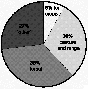
Florida's land is used as follows:
- 8% for crops
- 30% for pasture and range
- 35% for forest
- 27% for "other" -- transportation, parks, refuges, marshes, defense, industry, urban uses, golf courses, and mining areas.
The continued growth of urban land (cities) puts pressure on land prices and competition for water. In time, much of Florida’s agriculture will be replaced by urban land, by specialty fruit and vegetable operations, and by ornamentals. Public agencies are under increasing pressure to manage public lands to support the environment, the water supply, and recreation. Florida is a wonderful land. It is a home to many people and a place to visit for many more. It is also a very fragile land. It is important that wise decisions be made to protect this land of Florida for the generations to come.
| Home > Florida Then & Now > Supplemental Florida Reading Passages > Florida's Water Then and Now |
Exploring
Florida: A Social Studies Resource for Students and Teachers
Produced by the Florida Center for Instructional
Technology,
College of Education, University of South Florida © 2002.