|
|
|
| FL Maps > County > Sumter |
Click on a thumbnail image to view a full size version of that map.
Sumter County is Florida's 29th county, established on January 8, 1853, from a segment of Orange County. It gains its name from Thomas Sumter (1736-1832), a prominent general of southern campaigns during the Revolutionary War. Bushnell is the county seat.
For earlier maps of this area, visit the Orange County map gallery.
|
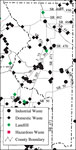
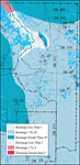
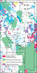
Withlacoochee River Watershed Distribution of Hazardous Waste Clean Up Sites, Landfills and Wastewater Facilities- Sumter County,
May 9, 2001 |
|
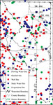
Withlacoochee River Watershed Distribution of Water Management Data Base Monitoring Sites- Sumter County,
May 9, 2001 |
|
Withlacoochee River Watershed Distribution of Soil Hydrologic Groups- Sumter County,
May 9, 2001 |
|
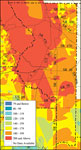
Withlacoochee River Watershed Ground Water Pollution Potential
to the Floridan Aquifer (D.R.A.S.T.I.C.)- Sumter County,
May 9, 2001 |
|
Withlacoochee River Watershed Recharge to/Discharge from the Floridan Aquifer In Inches Per Year- Sumter County,
May 9, 2001 |
|
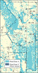
Withlacoochee River Watershed Distribution of FEMA 100-Year Flood Zones- Sumter County,
May 9, 2001 |
|
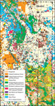
Withlacoochee River Watershed Distribution of 1995 Urban Land Use Within the FEMA 100-Year Flood Zone- Sumter County,
May 9, 2001 |
|
Withlacoochee River Watershed Distribution of Natural Systems - 1995- Sumter County,
May 9, 2001 |
|
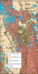
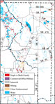
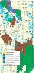
Withlacoochee River Watershed Distribution of Conservation Lands- Sumter County,
May 9, 2001 |
|
Withlacoochee River Watershed Strategic Habitat Conservation Areas, Areas of Conservation Interest, and Potential Natural Areas- Sumter County,
May 9, 2001 |
|
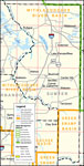
Southwest Florida Water Management District- Sumter County,
September 28, 2004 |
| First | Previous |
| FL Maps > County > Sumter |
Maps ETC
is a part of the
Educational Technology Clearinghouse
Produced by the
Florida Center for Instructional Technology
© 2007
College of Education
,
University of South Florida