|
|
|
| FL Maps > County > Bloxham |
Click on a thumbnail image to view a full size version of that map.
Bloxham County never actually existed. It was a proposed county, named for Governor William D. Bloxham, and was to incorporate lands from Levy and Marion Counties. The state legislature passed a bill in 1914 establishing the county, however voters failed to approve the proposal by referendum (1915), and therefore it existed on paper only.
For earlier maps of this area, visit the Levy County and Marion County map galleries.
Record 1 to 2 of 2
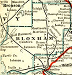
Bloxham County, 1917
A map of Bloxham County showing the proposed county lines, the proposed county seat (Williston), railroads, canals and principal auto routes connecting the major cities current to 1917. Bloxham County never actually existed. It was a proposed county...
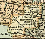
Bloxham County, 1920
A map of Bloxham County showing the proposed county lines, the proposed county seat (Williston), railroads, canals and principal auto routes connecting the major cities current to 1920. Bloxham County never actually existed. It was a proposed county...
FL Maps > County > Bloxham Maps ETC is a part of the Educational Technology Clearinghouse
Produced by the Florida Center for Instructional Technology © 2007
College of Education , University of South Florida