| FL Maps > Hurricanes and Tropical Storms |
Over 195 maps of hurricanes and tropical storms that have been near Florida. These maps are separated by year and by decade, by named storm so that one storm's route can be viewed as it moved, and other Florida hurricane maps, most of them NOAA images and pictures showing hurricanes approaching and affecting Florida. Also shown below are hurricane tracking of varying ranges so that hurricanes can be tracked as they form and move.
 | Storm Activity by Decade Gallery of 14 maps that show tropical storm and hurricane activity near Florida by decade from the 1850s to the 1990s. |
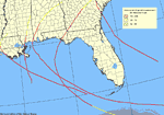
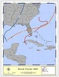 | Storms Activity by Year Gallery of 96 maps that show tropical storm and hurricane activity near Florida by year from 1892 to 2007. |
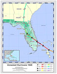 | Storms Activity by Name Gallery of 69 maps that show tropical storm and hurricane activity near Florida, and shows routes of named storms, including when and where they were declared hurricanes. |
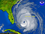 | Other Florida Hurricane Maps Gallery of 16 other Florida hurricane maps, including NOAA images and pictures from recent hurricanes, such as Charlie and Andrew. |
| FL Maps > Hurricanes and Tropical Storms |
Maps is a part of the Educational Technology Clearinghouse
Produced by the Florida Center for Instructional Technology © 2007
College of Education, University of South Florida