|
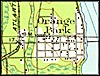
1917, Orange Park, Florida. Detail view from a United States Geological
Survey map. |
|
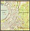
1949, Camp Blanding, Florida. Detail view from a United States Geological
Survey map. |
|
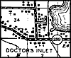
1940, Doctors Inlet, Florida. Detail view from a Florida State Road Department General Highway and Transportation map. |
|
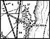
1940, Hibernia, Florida. Detail view from a Florida State Road Department General Highway and Transportation map. |
|
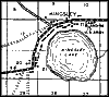
1940, Kingsley, Florida. Detail view from a Florida State Road Department General Highway and Transportation map. |
|
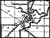
1940, Middleburg, Florida. Detail view from a Florida State Road Department General Highway and Transportation map. |
|
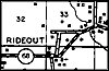
1940, Rideout, Florida. Detail view from a Florida State Road Department General Highway and Transportation map. |
|
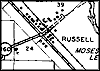
1940, Russel, Florida. Detail view from a Florida State Road Department General Highway and Transportation map. |
|
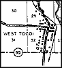
1940, West Tocoi, Florida. Detail view from a Florida State Road Department General Highway and Transportation map. |
|
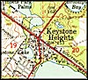
1949, Keystone Heights, Florida. Detail view from a United States
Geological Survey map. |