| Home > Maps > Florida Highway Map Key | |
Florida Highway Map Key
This key contains selected symbols used on Florida Highway Maps. The maps were produced over a number of years and there is some variation in the use of symbols from map to map. For example, on the older maps, a building shown in outline only indicates that the building was not in use when the map was drawn.
If you came to this page from an Exploring Florida map, this is a pop-up window. You can reposition this window to see both this key and your original map. When you are finished with this window, just close it to return to the map you were viewing.
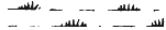
Roads: Divided Highway Paved Road -- High TypeBituminous Road -- Medium and Low TypeGravel or Stone Road Soil Surfaced Road Graded and Drained Road Unimproved Road Primitive Road Impassable Road Private Road Federal Aid Highway Federal Aid Primary Highway Federal Aid Secondary Highway U.S. Numbered Highways State Highway Bridge, Highway Drawbridge, Highway Highway Grade Separation Railroads: Railroad Railroad Station or Prepay Station Railroad Grade Crossing Water Features: Narrow Stream Wide Stream or
Dam 
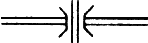
Ferry("FF" Free Ferry "TF" Toll Ferry) Dock, Pier, or Landing Flood Control Spillway Canal Drainage Ditch Levee or Dike with Road Lake or Pond Intermittent Pond Yacht Basin Marsh Swamp Land Land Exposed at Low Water Boundaries: County Boundary Line Civil Township Boundary Land Section Line State Survey Section Line Corporate Limits Indian Reservation (older maps) Wildlife Management Area County Park Seminole Indian Reservation (newer maps) Towns: County Seat Other City or Village Seminole Indian Village Buildings: or
Dwelling or
Rows or Groups of Dwellings Farm Unit School Church Post Office Townhall or Community Hall Tourist Court or Motel Hotel Hospital Correctional Institution Fort Seasonal Dwelling Tenant House Barracks, Dormitories, or Migrant Quarters Businesses: Business Business and Dwelling Citrus Packing House Turpentine Still Saw Mill Stock Yard -- Loading Pen or CorralDairy Mine Factory Recreational Facilities: Camp or Lodge Camp Site, Trailer Park Race Track Picnic Ground Playground, Ball Field Monument Miscellaneous: or
Airport ("B" indicates housing facilities) Power Plant Radar Station Forest Ranger Station or Fire Control Headquarters Game Checking Station State Road Department Camp Radio or TV Control Tower Lookout Tower Cattle Guard Pumping Station Gauging or Small Pumping Station Locked Gate or Fence Cemetery Water Tank CCC Camp Directional Arrow Triangulation Station with Name Location of Symbol
| Home > Maps > Florida Highway Map Key |
Exploring
Florida: A Social Studies Resource for Students and Teachers
Produced by the Florida Center for Instructional
Technology,
College of Education, University of South Florida © 2004.