Hernando
County Maps
(Benton County, 1844-1850)
Click
on a thumbnail image to view a full size version of that map.
Hernando
County is Florida's 22nd county, established on February 24, 1843,
from segments of Hillsborough County,
Mosquito County, and Alachua
County. It is one of two counties that gains its name from Hernando de
Soto, a famous Spanish explorer. From March 6, 1844, till December 24, 1850,
the county was renamed Benton in honor of Thomas Hart Benton. He gained this
honor for sponsoring the Armed Occupation Act of 1842, which was favored by
Floridians wanting to evict the Native Americans. He later fell out of favor
and the name was changed back to Hernando. Brooksville is the county seat.
For earlier
maps of this area, visit the Hillsborough
County, Mosquito County, and Alachua
County map galleries.
Record
26 to
50 of
94
|
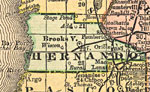
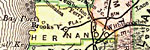
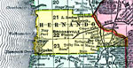
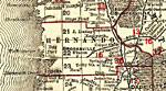
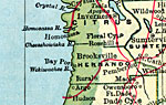
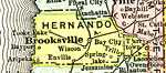
Hernando County,
1890
A map of Hernando County showing county lines, the county seat (Brooksville), railroads, and cities current to 1890....
|
|
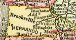
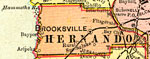
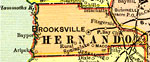
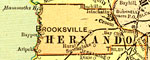
Hernando County,
1890
A map of Hernando County showing the county seat (Brooksville), cities, towns, rivers, lakes, roads, and railroads present in 1890....
|
|
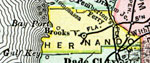
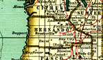
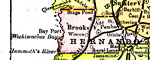
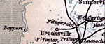
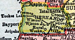
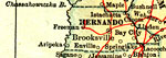
Hernando County,
1892
This detail of a map of Florida indicates Hernando County current to 1892. Major waterways are shown with thin, concentric lines. The thick black lines represent railroads. The central features of the detail include Brooksville, Oriole, and Bayport....
|
|
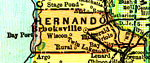
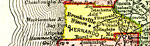
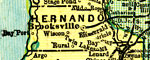
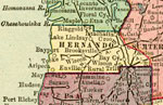
Hernando County,
1893
A map of Hernando County showing county lines, the county seat (Brooksville), and railroads connecting the major cities current to 1893....
|
|
Hernando County,
1894
A map of Hernando County showing county lines, the county seat (Brooksville), railroads, and cities current to 1894....
|
|
Hernando County,
1895
This Florida map of Hernando County outlines the county boundary and railroads connecting the major cities, current to 1895. ...
|
|
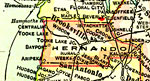
Hernando County,
1897
A map of Hernando County showing forts, towns, bodies of water, county lines, the county seat (Brooksville), and railroads connecting the major cities current to 1897. Township and Range grids extending from the Tallahassee Meridian and Tallahassee B...
|
|
Hernando County,
1898
A map of Hernando County showing county lines, the county seat (Brooksville), and railroads connecting the major cities current to 1898....
|
|
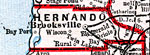
Hernando County,
1898
Digitization provided by the USF Libraries Digitization Center. Rare Maps. This is a detail map of Hernando county circa 1898. This map shows section township range (STR). Main cities and towns are shown such as the county seat Brooksville. Inland wa...
|
|
Hernando County,
1899
A map of Hernando County showing county lines, the county seat (Brooksville), and railroads connecting the major cities current to 1899....
|
|
Hernando County,
1900
A map of Hernando County showing county lines, the county seat (Brooksville), railroads, and cities current to 1900....
|
|
Hernando County,
1900
A map of Hernando County showing county lines, the county seat (Brooksville), railroads, and cities current to 1900....
|
|
Florida Railroads - Hernando County,
1900
This detail of Hernando County shows railroads, county boundaries, wetlands, cities, towns, villages, post offices, lakes, and rivers current to 1900. There are 33 railroad lines listed on the main map, as a guide to the numbering. The map was a pock...
|
|
Hernando County,
1902
A map of Hernando County showing county lines, the county seat (Brooksville), and railroads connecting the major cities current to 1902....
|

|
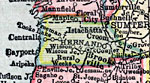
Hernando County,
1902
This is a detail of a map of Florida, displaying county borders, county seats, and railroads current to 1902 for Hernando County. Major and minor cities are shown, as well as major waterways. The features of the map include Brooksville, Fitzgerald, a...
|
|
Hernando County,
1904
A map of Hernando County showing county lines, the county seat (Brooksville), railroads, and cities current to 1904....
|
|
Hernando County,
1904
This detail of Hernando County is taken from a handbook for travelers by Karl Baedeker current to 1904. Though made in Leipzig, Germany, the detail was based upon government topographic surveys. It shows footpaths, railways, and roads wherever possib...
|
|
Hernando County,
1907
A map of Hernando County showing county lines, the county seat (Brooksville), and railroads connecting the major cities current to 1907....
|
|
Hernando County,
1909
A map of Hernando County showing county lines, the county seat (Brooksville), and railroads connecting the major cities current to 1909....
|
|
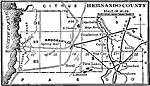
Hernando County,
1910
This detail of a map of Florida shows county boundaries, roads, cities, towns, villages, lakes, and rivers current to 1910 for Hernando County. On the main map, counties and major cities and towns are listed along the left and bottoms edges with corr...
|
|
Hernando County,
1911
A map of Hernando County showing county lines and railroads connecting the major cities current to 1911....
|
|
Hernando County,
1911
A map of Hernando County showing county lines, the county seat (Brooksville), railroads, and cities current to 1911....
|
|
Hernando County,
1914
A map of Hernando County showing county lines, the county seat (Brooksville), railroads, and cities current to 1914....
|
|
Hernando County,
1916
This map of Hernando County shows the county seat (Brooksville), county boundaries, wetlands, railroads, and cities current to 1916....
|
|
Hernando County,
1916
This detail of a map of Florida shows county boundaries, roads, cities, towns, villages, lakes, and rivers current to 1916 for Hernando County. This detail has counties and major cities and towns listed in larger font. The counties are also colored f...
|
Maps ETC
is a part of the
Educational Technology Clearinghouse
Produced by the
Florida Center for Instructional Technology
© 2007
College of Education
,
University of South Florida