Click on a thumbnail sketch to view the full-sized map.
 |
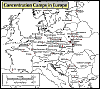
Self-Pronouncing Map of the Nazi Camp System. Click on this interactive map for descriptions and pronunciations of the major camps. | |
 |
Expulsions. Map of Jewish expulsions and resettlement areas in Europe, 1100-1500. | |
 |
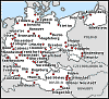
Pogroms. Map of pogroms and antisemitic acts of violence in Russia and the Pale from 1871-1906. | |
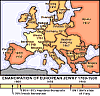 |
Emancipation of European Jewry. Map of Europe showing the date of the emancipation of Jews by country from 1789 to 1930. | |
 |
Kristallnacht. Map of the Nazi violence against Jewish synagogues, November 9, 1938. | |
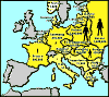 |
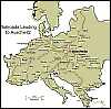
Jewish Population of Europe, 1939. Map of Europe showing the total Jewish population of each country in 1939. | |
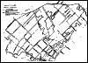 |
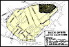
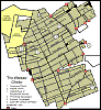
Bialystok Ghetto, April 2, 1943. Over 50,000 people lived in the Bialystok Ghetto at the end of 1941. The (eastern) boundary of the ghetto was Sienkiewicz Street, renamed on the map as "Erich Koch Street." | |
 |
Bialystok Ghetto Revolt. August 16, 1943, was the beginning of an armed revolt in the Bialystok ghetto prepared by the United Anti-Fascist Bloc (Communists, Dror, Hashomer Hatsair, and the Bund). | |
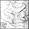 |
Six Major Death Camps. Map of the six major death camps in occupied Poland. | |
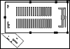 |
Dachau. Map of Dachau, the first Nazi concentration camp located in Southern Germany. | |
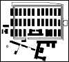 |
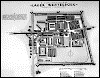
Auschwitz. Map of the Auschwitz concentration camp located in what is now Poland. | |
 |
Treblinka. Map of Treblinka showing locations of buildings at former extermination camp. Adapted from a sign at the memorial site. | |
| Westerbork Transit Camp. Until July 1942, Westerbork was a refuge camp for Jews who had moved illegally to the Netherlands. After the Nazi conquest of Holland, it was operated as a transit camp until April 1944. | |
 |
 |
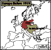
Europe before 1919. Map of Europe showing Germany and Austria-Hungary before the Treaty of Versailles. Choice of color map for display on computer screen (left) or blackline master in PDF format for printing (right). |
 |
 |
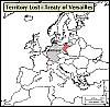
Territory lost after the 1919 Treaty of Versailles. Map showing territory lost by Germany and Austria-Hungary after the First World War. Choice of color map for display on computer screen (left) or blackline master in PDF format for printing (right). |
 |
 |
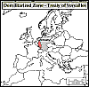
Demilitarized Zone-Treaty of Versailles. Map of Germany and Austria-Hungary after the Treaty of Versailles marking the demilitarized zone. Choice of color map for display on computer screen or blackline master in PDF format for printing (right). |
 |
 |
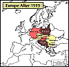
Europe after 1919. Map of Europe after the Treaty of Versailles (1919). Choice of color map for display on computer screen (left) or blackline master in PDF format for printing (right). |
 |
 |
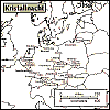
Kristallnacht. Map plotting concentrated areas of Nazi violence against Jews during the infamous "Kristallnacht". Choice of color map for display on computer screen (left) or blackline master in PDF format for printing (right). |
 |
 |
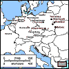
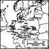
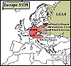
Central Europe 1939. Map showing: the Sudetenland, the new protectorate of Bohemia-Moravia, and how Poland was divided after its invasion. Choice of color map for display on computer screen (left) or blackline master in PDF format for printing (right). |
 |
 |
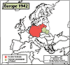
Greater Germany 1942. Map of Greater Germany in November of 1942 showing territories annexed by the Reich. Choice of color map for display on computer screen (left) or blackline master in PDF format for printing (right). |
 |
 |
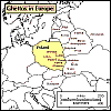
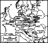
Ghettos in Europe. Map showing Jewish ghettos in Europe under the Nazis. Choice of color map for display on computer screen (left) or blackline master in PDF format for printing (right). |
 |
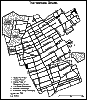 |
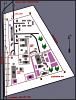
The Warsaw Ghetto. Map of the Warsaw Ghetto in what is now Poland. Choice of color map for display on computer screen (left) or blackline master in PDF format for printing (right). |
 |
 |
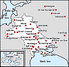
Railroads Leading to Auschwitz. Map of the rail system that brought victims to the Auschwitz concentration camp. Choice of color map for display on computer screen (left) or blackline master in PDF format for printing (right). |
 |
 |
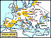
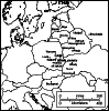
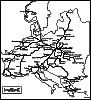
Nazi Camp System. Map of transit, concentration, and extermination camps in Europe. Choice of color map for display on computer screen (left) or blackline master in PDF format for printing (right). |
 |
 |
Rescue of Danish Jews. Map plotting the rescue routes of Danish Jews. Choice of color map for display on computer screen (left) or blackline master in PDF format for printing (right). |
 |
 |
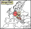
Central Europe 1945. Map of Central Europe as it looked at the end of the war. Choice of color map for display on computer screen (left) or blackline master in PDF format for printing (right). |
 |
Central Europe Today. Map of Central Europe today. Blackline master in PDF format. | |
 |
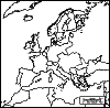
Europe Today. Map of Europe today. Blackline master in PDF format. | |
National Geographic's Xpeditions site provides hundreds of maps for non-commercial use.
![]()
![]()