 |
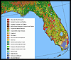
This
data set is an Arc/INFO grid map of land cover characteristics for North
America, published by the U.S. Geological Survey. The data were compiled by
staff at the EROS Data Center as part of the Global Land Cover Characterization
Project. The land cover classes were produced using 1-km AVHRR data from
April 1992 to March 1993. |
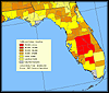 |
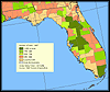
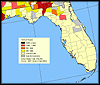
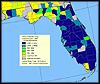
Information
about "Cattle and Calves-Inventory" from Agriculture Census
of the United States map, published by the U.S. Geological Survey. This is
a revised version of the April, 2000, data set. |
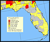 |
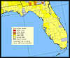
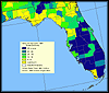
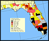
Information
about "Broiler and Other Meat-Type Chickens Sold" from Agriculture
Census of the United States map, published by the U.S. Geological Survey.
This is a revised version of the April, 2000, data set. |
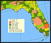 |
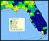
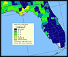
Information
about "Total Cropland" from Agriculture Census of the United
States map, published by the U.S. Geological Survey. This is a revised version
of the April, 2000, data set. |
 |
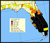
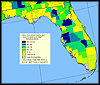
Information
about "Number of Farms" from Agriculture Census of the United
States map, published by the U.S. Geological Survey. This is a revised version
of the April, 2000, data set. |
 |
Information
about "Hogs and Pigs-Inventory" from Agriculture Census of the
United States map, published by the U.S. Geological Survey. This is a revised
version of the April, 2000, data set. |
 |
Information
about "Irrigated Land in Farms" from Agriculture Census of the
United States map, published by the U.S. Geological Survey. This is a revised
version of the April, 2000, data set. |
 |
Information
about "Land in Orchards" from Agriculture Census of the United
States map, published by the U.S. Geological Survey. This is a revised version
of the April, 2000, data set. |
 |
Information
about "Acres of Pecans" from Agriculture Census of the United
States map, published by the U.S. Geological Survey. This is a revised version
of the April, 2000, data set. |
 |
Information
about "Value of Crops Sold" from Agriculture Census of the United
States map, published by the U.S. Geological Survey. This is a revised version
of the April, 2000, data set. |
 |
Information
about "Market Value of Agricultural Products Sold" from Agriculture
Census of the United States map, published by the U.S. Geological Survey.
This is a revised version of the April, 2000, data set. |
 |
Information
about "Value of Livestock, Poultry, and their Products Sold"
from Agriculture Census of the United States map, published by the U.S. Geological
Survey. This is a revised version of the April, 2000, data set. |
 |
Information
about "Value of Nursery Crops Grown for Sale" from Agriculture
Census of the United States map, published by the U.S. Geological Survey.
This is a revised version of the April, 2000, data set. |
 |
Information
about "Vegetables Harvested for Sale" from Agriculture Census
of the United States map, published by the U.S. Geological Survey. This is
a revised version of the April, 2000, data set. |