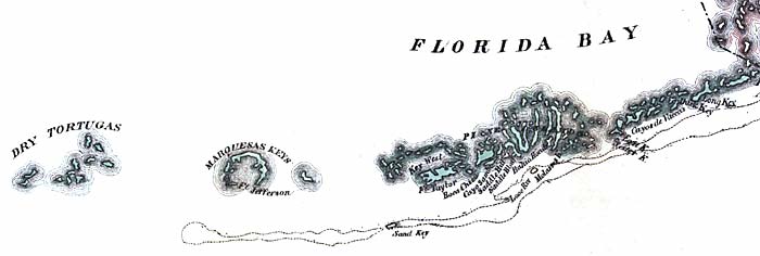
Description: This detail of a map from the annual report of the Surveyor General in 1856 shows Monroe County. Drainage, cities and towns, roads, trails, and location of railroad lines are shown in great detail. The major feature of detail is the Florida Keys. Of these, many are labeled, including Dry Tortugas, Marquesas Keys, Fort Jefferson, and Key West.
Place Names: Monroe, Dry Tortugas, Marquesas Keys, Fort Jefferson, Keey West, Long Key, Sand Key,
ISO Topic Categories: boundaries, inlandWaters, oceans, society, transportation
Keywords: Monroe County - Keys, physical, political, transportation, physical features, major political subdivisions, county borders, local jurisdictions, roads, railroads, boundaries, inlandWaters, oceans, society, transportation, Unknown,1856
Source: Columbus Drew, (Jacksonville, FL: Columbus Drew, 1856)
Map Credit: Courtesy of the Geography and Map Division of the Library of Congress |
|