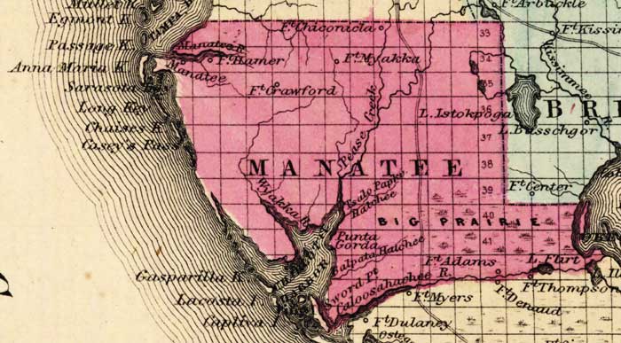
Description: This detail of a map of Florida was "Entered according to Act of Congress in the year 1863 by A. J. Johnson in the clerks office of the District Court of the United States for the Southern District of New York." It shows Manatee County in color, towns, villages, county seats, forts, railroads, and roads. The main features of the detail are Charlotte Harbor and Fort Myakka.
Place Names: Manatee, Charlotte Harbor, Fort Myakka Fort Harner, Fort Chiconicla, Fort Grawford, Lake istokpoga, Manatee River, Punta Gorda, Caloosahachee River, Fort Adams, Big Prairie, Pease Creek, Passage Key, Anna Maria Key, Sarasota Bay, Long Key, Chaises Key, Casey's Pass, Gasparilla Key, Lacosta Island, Cative Island, Lake Flirt,
ISO Topic Categories: boundaries, inlandWaters, oceans, transportation
Keywords: Manatee County, physical, political, historical, transportation, physical features, county borders, railroads, roads, water routes, boundaries, inlandWaters, oceans, transportation, Unknown,1863
Source: Johnson, A.J., Johnson's New Illustrated Family Atlas (New York, NY: Johnson and Ward, 1863) 40
Map Credit: Courtesy the private collection of Roy Winkelman. |
|