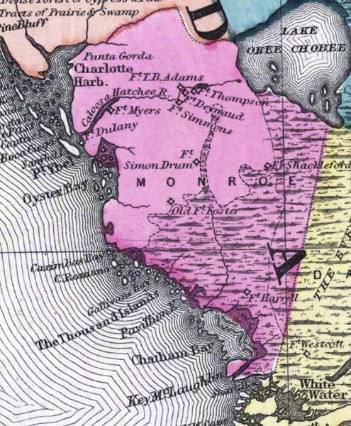
Description: This detail of a 1873 map of Florida, Georgia, and South Carolina shows an in color portrait of county lines of the period, Florida railroad routes, forts, and outlines major waterways for the mainland of Monroe County. The major water features of the detail are Chatcham Bay, Ostyer Bay, and Lake Okeechobee. Other features include Ten Thousand Islands, Cape Romano, and Charlotte Harbor.
Place Names: Monroe, Charlotte Harbor, Cape Romano, Cape Sable, Punta Gorda, Caloosahatchee, Fort Myers, Fort Dulaney, Fort Simmons, Fort Simon, Oyster Bay, Point Ybel, Captive Island, Captive Pass, Boca Grande, Gasparilla Keey, Fort Thompson, Fort Deynaud, Fort Shackleford, Old Fort Foster, Caximbas Bay, Gallivans Bay, Ten Thousand Islands, Pavillon Key, Chatham Bay, Key McLaughlin, Fort Harrell, Lake Okeechobee,
ISO Topic Categories: boundaries, inlandWaters, oceans, transportation
Keywords: Monroe County - Mainland, physical, political, transportation, physical features, major political subdivisions, county borders, railroads, boundaries, inlandWaters, oceans, transportation, Unknown,1873
Source: Simon J. Martenet, New topographical atlas of the State of Ohio (, : Stedman, Brown & Lyon/H.H. Lloyd and Co., 1873) 89
Map Credit: Courtesy of the private collection of Roy Winkelman |
|