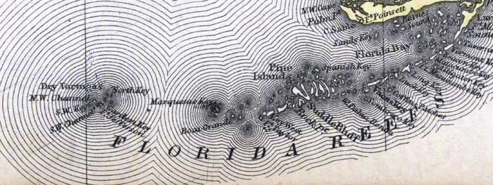
Description: This detail of a 1873 map of Florida, Georgia, and South Carolina shows an in color portrait of county lines of the period, Florida railroad routes, forts, and outlines major waterways for the lower keys of Monroe County. The major water features of the detail are Barnes Sound and the Florida Bay. Other features include Key West, Pine Islands, and the Dry Tortugas.
Place Names: Monroe, Barnes Sound, Beacon Key, Matacombe Key, Alligator Key, Long Key, Vacas Key, Sombrero Key, Saddle Bluff, Spanish Key, Pine Islands, Rock Point, Key West, Fort Taylor, Boca Grande, Marquesas Keys, North Key, Dry Tortugas, Garden Key, Fort Jefferson
ISO Topic Categories: boundaries, inlandWaters, oceans, transportation
Keywords: Monroe County - Lower Keys, physical, political, transportation, physical features, major political subdivisions, county borders, railroads, boundaries, inlandWaters, oceans, transportation, Unknown,1873
Source: Simon J. Martenet, New topographical atlas of the State of Ohio (, : Stedman, Brown & Lyon/H.H. Lloyd and Co., 1873) 89
Map Credit: Courtesy of the private collection of Roy Winkelman |
|