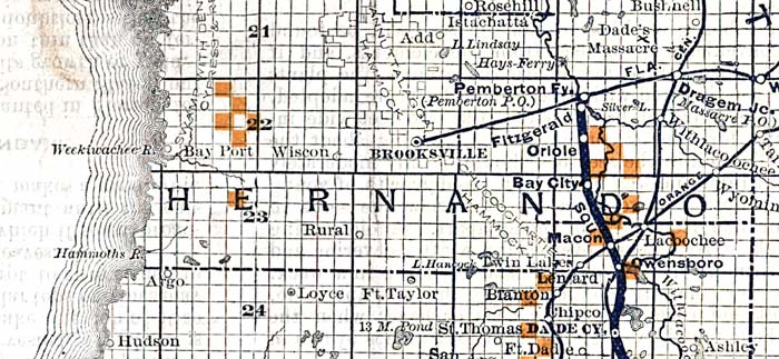
Description: This detail shows county lines and county seats current to the period, major towns and cities, and railroad routes and stations for Hernando County. The Townships are subdivided into sections, and those sections offered for sale by the land department of the South Florida R.R. Company are shown in orange. Map scale is 1:633,600. Notable features of the detail include Brooksville, Dade City, and Hudson.
Place Names: Hernando, Add, Istachata, Dade's Massacre, Bushnell, Dragem, Fitzgerald, Oriole, Bay City, Brooksville, Macon, Owensboro, Branton, Dade City, Rural, Loyce, Fort Taylor, Wiscon, Hudson, Weekiwachee River, Lacoochee,
ISO Topic Categories: boundaries, inlandWaters, oceans, transportation
Keywords: Hernando County, physical, political, transportation, physical features, major political subdivisions, county borders, local jurisdictions, railroads, boundaries, inlandWaters, oceans, transportation, Unknown,1888
Source: D. H. Elliott, (Sanford, FL: South Florida R. R. Co. and the Plant Investment Co, 1888)
Map Credit: Courtesy the private collection of Roy Winkelman |
|