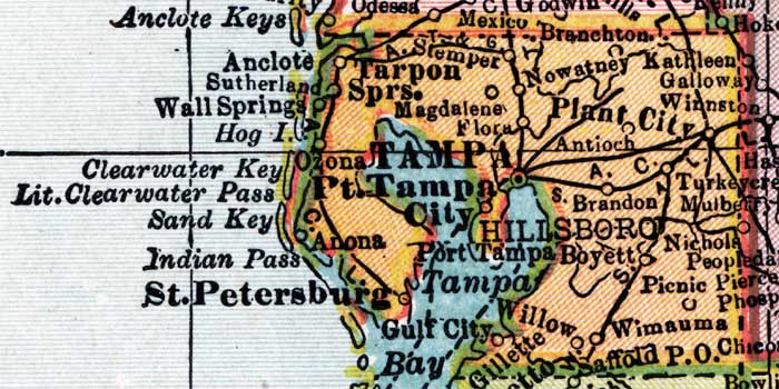
Description: This detail of a map of Florida shows county boundaries, roads, cities, towns, villages, lakes, and rivers current to 1910 for Hillsborough County. On the main map, counties and major cities and towns are listed along the left and bottoms edges with corresponding coordinates. The counties are also colored for ease of differentiation. The main features of this detail include Brandon, Tampa, and Plant City.
Place Names: Hillsborough, Anclote, Sutherland, Wall Springs, Hog Island, Clearwater Key, Little Clearwater Pass, Sand Key, Indian Pass, Saint Patersburg, Tarpon Springs, Stemper, Magdalene, Flora, Tampa, Port Tampa, Tampa Bay, Gulf City, Gillette, Willow, Wimauma, Picnic, Nichole, Mulberry, Brandon, Antioch, Plant City, Winnston, Galloway, Kathleen, Nowatney, Branchton,
ISO Topic Categories: boundaries, transportation, inlandWaters, oceans
Keywords: Hillsborough County, physical, political, transportation, swamps, everglades, wetlands, physical features, county borders, roads, boundaries, transportation, inlandWaters, oceans, Unknown,1910
Source: , Atlas of the World (New York, NY: C.S. Hammond & Company, 1910) 84
Map Credit: Courtesy the private collection of Roy Winkelman. |
|