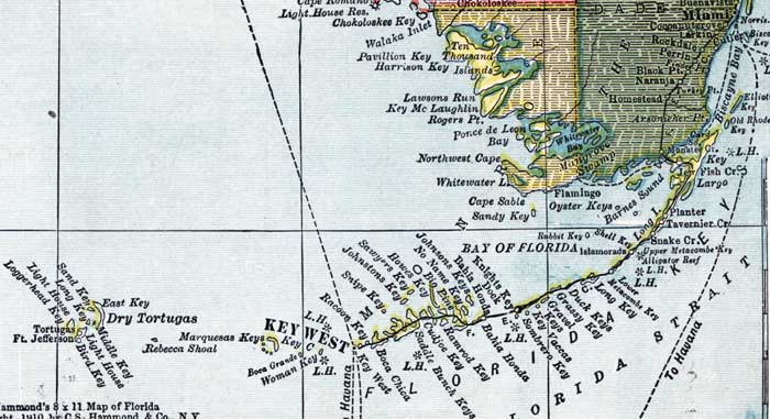
Description: This detail of a map of Florida shows county boundaries, roads, cities, towns, villages, lakes, and rivers current to 1910 for Monroe County. On the main map, counties and major cities and towns are listed along the left and bottoms edges with corresponding coordinates. The counties are also colored for ease of differentiation. The main features of this detail include Ten Thousand Islands, Cape Sable, and Key West.
Place Names: Monroe, Ten Thousand Island, Pvaillion Key, Harrison Key, Lawsons Run, Key McLaughlin, Ponce De Leon, Cape Sable, Sandy Key, Barnes Sound, Key LArgo, Planter, Tavernier, Snake Creek, Duck Keys, Grassy Key, Gravel Keys, Key Vaccas, Sombrero Key, Knights Key, Bahia Honda, Johnsons Keys, No Name Key, Big Pine, Howes Key, Ramrod Key, Cudjoe, Saddle Bunch Key, Sawyers Key, Johnstons Key, Snipe Key, Racoon Key, Boca Chica, Key West, Marquesas Keys,
ISO Topic Categories: boundaries, transportation, inlandWaters, oceans
Keywords: Monroe County, physical, political, transportation, swamps, everglades, wetlands, physical features, county borders, roads, boundaries, transportation, inlandWaters, oceans, Unknown,1910
Source: , Atlas of the World (New York, NY: C.S. Hammond & Company, 1910) 84
Map Credit: Courtesy the private collection of Roy Winkelman. |
|