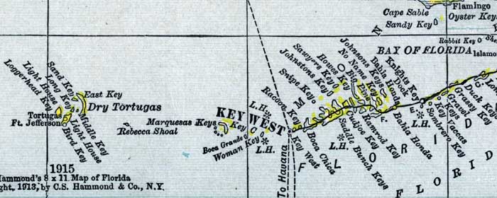
Description: This detail of a map of Florida shows county boundaries, roads, cities, towns, villages, lakes, and rivers current to 1916 for Monroe County. This detail has counties and major cities and towns listed in larger font. The counties are also colored for ease of differentiation. Features of this detail include the Bay of Florida, Key West, and the Dry Tortugas.
Place Names: Monroe, Duck Keys, Grassy Key, Gravel Keys, Key Vaccas, Sombrero Key, Knights Key, Bahia Honda, Big Pine, Howes Key, Sawyers Key, Johnstons Key, Snipe Key, Racoon Key, Boca Chica, Key West, Dry Tortugas, Sand Key, Bird Key, Fort Jefferson,
ISO Topic Categories: boundaries, transportation, inlandWaters, oceans
Keywords: Monroe County - Lower Keys, physical, political, transportation, swamps, everglades, wetlands, physical features, county borders, roads, boundaries, transportation, inlandWaters, oceans, Unknown,1916
Source: , New Reference Atlas of the World (New York, NY: C.S. Hammond & Company, 1916) 84
Map Credit: Courtesy the private collection of Roy Winkelman. |
|