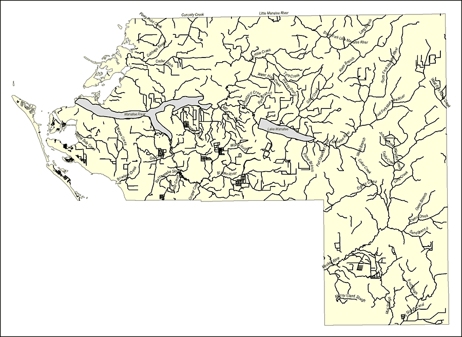
Description: This map was created by FCIT and shows the waterways of Manatee County. All major rivers, streams, creeks, lakes, and swamps are labeled. This map features Curiosity Creek, Piney Point Creek, Frog Creek, Cabbage Slough, Cedar Drain, Manatee River, Wares Creek, Palma Sola Creek, Bowlees Creek, Gap Creek, Sugarhouse Creek, Rattlesnake Slough, Cedar Creek, Cooper Creek, Braden River, Mill Creek, Wolf Slough, Gamble Creek, Water Hole Creek, Tyre Creek, Harvey Prong, Goddard Creek, Rye Branch, Lake Manatee, Gilley Creek, Fisher Branch, Fort Crawford Creek, Manatee River, Webb Branch, Coker Creek, Ogleby Creek, Johnson Creek, Wingate Creek, Taylor Creek, Long Creek, Owen Branch, Owen Creek, Sand Branch, North Fork Manatee River, West Fork Manatee River, Keen Branch, South Fork Manatee River, Myakka River, Mossy Island Slough, Bud Slough, Big Slough Canal, and Mossy Island Slough.
Place Names: Manatee, Curiosity Creek, Piney Point Creek, Frog Creek, Cabbage Slough, Cedar Drain, Manatee River, Wares Creek, Palma Sola Creek, Bowlees Creek, Gap Creek, Sugarhouse Creek, Rattlesnake Slough, Cedar Creek, Cooper Creek, Braden River, Mill Creek, Wolf Slough, Gamble Creek, Water Hole Creek, Tyre Creek, Harvey Prong, Goddard Creek, Rye Branch, Lake Manatee, Gilley Creek, Fisher Branch, Fort Crawford Creek, Manatee River, Webb Branch, Coker Creek, Ogleby Creek, Johnson Creek, Wingate Creek, Taylor Creek, Long Creek, Owen Branch, Owen Creek, Sand Branch, North Fork Manatee River, West Fork Manatee River, Keen Branch, South Fork Manatee River, Myakka River, Mossy Island Slough, Bud Slough, Big Slough Canal, Mossy Island Slough,
ISO Topic Categories: boundaries, inlandWaters
Keywords: Florida Waterways: Manatee County Outline, political, physical, kriversandstreams, physical features, county borders, photograph in shape of map, photo, Florida mapboundaries, inlandWaters, 2008
Source: Florida Center for Instructional Technology, (Tampa, FL: University of South Florida, 2008)
Map Credit: Courtesy of the Florida Center for Instructional Technology |
|