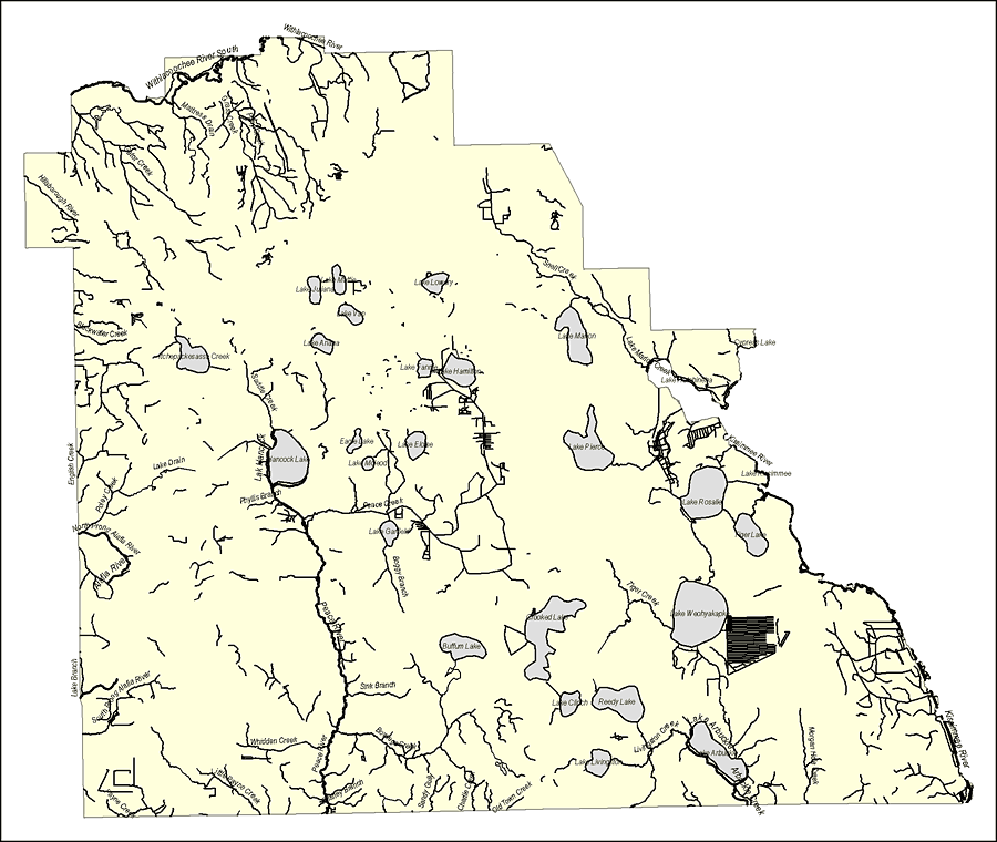
Description: This map was created by FCIT and shows the waterways of Polk County. All major rivers, streams, creeks, lakes, and swamps are labeled. This map features Withlacoochee River, Withlacoochee River South, Mattress Drain, Grass Creek, Pony Creek, Gator Creek, Hillsborough River, Blackwater Creek, Itchepackesassa Creek, Saddle Creek, English Creek, Poley Creek, Lake Drain, Lake Hancock, Phyllis Branch, Hancock Lake, Eagle Lake, Lake McIeod, Lake Eloise, Peace Creek, Lake Fannie, Lake Hamilton, Lake Ariana, Lake Van, Lake Juliana, Lake Mattie, Lake Lowery, Smell Creek, Lake Marion Creek, Lake Marion, London Creek, Lake Pierce, Lake Hatchineha, Cypress Lake, Kissimmee River, Lake Kissimmee, Lake Rosalie, Lake Garfield, North Prong Alafia River, Alafia River, Tiger Lake, Boggy Branch, Peace River, Crooked Lake, Lake Weohyakapka, Buffum Lake, Lake Branch, South Prong Alafia River, Payne Creek, Little Payne Creek, Whidden Creek, Gilshey Branch, Sink Branch, Bowlegs Creek, Sandy Gully, Charlie Creek, Old Town Creek, Lake Clinch, Reedy Lake, Lake Livingston, Livingston Creek, Lake Arbuckle, Arbuckle Creek, and Morgan Hole Creek.
Place Names: Polk, Withlacoochee River, Withlacoochee River South, Mattress Drain, Grass Creek, Pony Creek, Gator Creek, Hillsborough River, Blackwater Creek, Itchepackesassa Creek, Saddle Creek, English Creek, Poley Creek, Lake Drain, Lake Hancock, Phyllis Branch, Hancock Lake, Eagle Lake, Lake McIeod, Lake Eloise, Peace Creek, Lake Fannie, Lake Hamilton, Lake Ariana, Lake Van, Lake Juliana, Lake Mattie, Lake Lowery, Smell Creek, Lake Marion Creek, Lake Marion, London Creek, Lake Pierce, Lake Hatchineha, Cypress Lake, Kissimmee River, Lake Kissimmee, Lake Rosalie, Lake Garfield, North Prong Alafia River, Alafia River, Tiger Lake, Boggy Branch, Peace River, Crooked Lake, Lake Weohyakapka, Buffum Lake, Lake Branch, South Prong Alafia River, Payne Creek, Little Payne Creek, Whidden Creek, Gilshey Branch, Sink Branch, Bowlegs Creek, Sandy Gully, Charlie Creek, Old Town Creek, Lake Clinch, Reedy Lake, Lake Livingston, Livingston Creek, Lake Arbuckle, Arbuckle Creek, Morgan Hole Creek,
ISO Topic Categories: boundaries, inlandWaters
Keywords: Florida Waterways: Polk County Outline, political, physical, kriversandstreams, physical features, county borders, photograph in shape of map, photo, Florida mapboundaries, inlandWaters, 2008
Source: Florida Center for Instructional Technology, (Tampa, FL: University of South Florida, 2008)
Map Credit: Courtesy of the Florida Center for Instructional Technology |
|