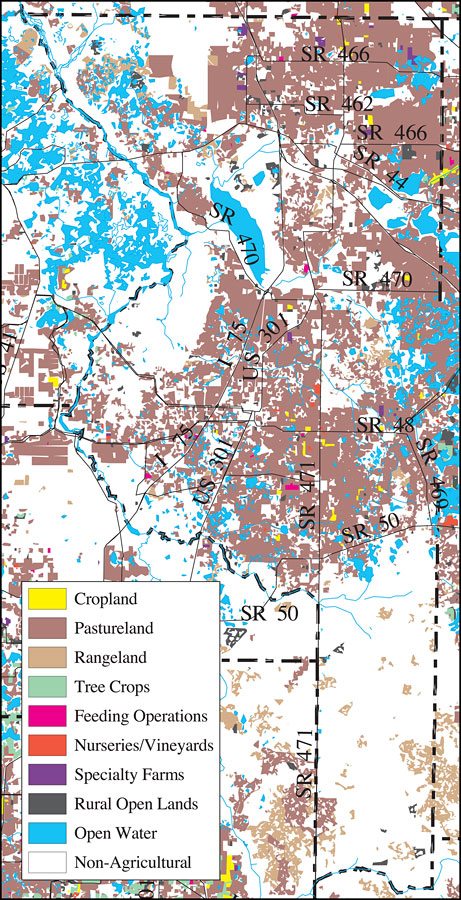
Description: This is a detail map of Sumter County extracted from the Southwest Florida Watershed Management District or SWFWMD Withlacoochee River Distribution of 1995 Agricultural Land Use/Cover map, created on May 9, 2001. Agricultural land use/cover classifications shown are cropland (yellow), pastureland (brown), rangeland (off white), tree crops (green), feeding operations (fuchsia) , nurseries/vineyards (orange), specialty farms (purple), rural open lands (dark gray) and open water (blue). It also shows non-agricultural land use (white), major roads, inland water, and county boundaries. From the original map: "Land use and cover data were photointerpreted from 1:24,000 and 1:40,000 scale color infrared aerial photographs taken between October of 1994 and May of 1995. Land use and cover data are classified utilizing the Florida Department of Transportation Land Use, Cover and Forms Classification (FLUCCS) System." —Southwest Florida Watershed Management District
Place Names: Sumter, Sumter, �Sumter County
ISO Topic Categories: boundaries, �geoscientificInformation, �inlandWaters, �transportation
Keywords: Withlacoochee River Watershed Distribution of 1995 Agricultural Land Use/Cover- Sumter County, physical, �political, �transportation, �hydrological, �watershed, �kwatershed, physical features, county borders, roads, boundaries, �geoscientificInformation, �inlandWaters, �transportation, Unknown,May 9, 2001
Source: Southwest Florida Water Management District, Withlacoochee River Comprehensive Watershed Management Plan Atlas, Withlacoochee River Watershed Distribution of 1995 Agricultural Land Use/Cover Map (Brooksville, FL: Southwest Florida Water Management District, 2001)
Map Credit: Courtesy of the Southwest Florida Water Management District |
|