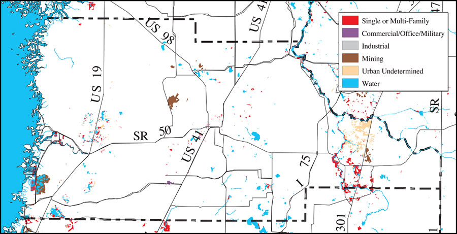
Description: This is a detail map of Hernando County extracted from the Southwest Florida Watershed Management District or SWFWMD Withlacoochee River watershed distribution of 1995 urban land use within the FEMA 100-year flood zone map, created on May 9, 2001. The following urban land use classifications are shown by color: single or multi-family (red), commercial/office/military (purple), industrial (gray), mining (brown), and urban undetermined (beige). It also shows US/State roads, inland water and county boundaries. "Land use and cover data were interpreted from 1:24,000 and 1:40,000 scale color infrared aerial photographs taken between October of 1994 and May of 1995. Land use and cover data are classified utilizing the Florida Department of Transportation Land Use, Cover and Forms Classification (FLUCCS) System. The flood zone information was digitized from the Federal Emergency Management Agency's (FEMA) Flood Insurance Rate Map (FIRM) panels. These data were overlayed in the District's GIS to obtain the areas of urban development within the 100-year flood plain in 1995. These data are intended to provide a generalized view of this region." —Southwest Florida Watershed Management District
Place Names: Hernando, Hernando, �Hernando County
ISO Topic Categories: boundaries, �geoscientificInformation, �inlandWaters, �transportation
Keywords: Withlacoochee River Watershed Distribution of 1995 Urban Land Use Within the FEMA 100-Year Flood Zone- Hernando County, physical, �political, �transportation, �hydrological, �watershed, �kwatershed, physical features, county borders, roads, boundaries, �geoscientificInformation, �inlandWaters, �transportation, Unknown,May 9, 2001
Source: Southwest Florida Water Management District, Withlacoochee River Comprehensive Watershed Management Plan Atlas, Withlacoochee River Watershed Distribution of 1995 Urban Land Use Within the FEMA 100-Year Flood Zone Map (Brooksville, FL: Southwest Florida Water Management District, 2001)
Map Credit: Courtesy of the Southwest Florida Water Management District |
|