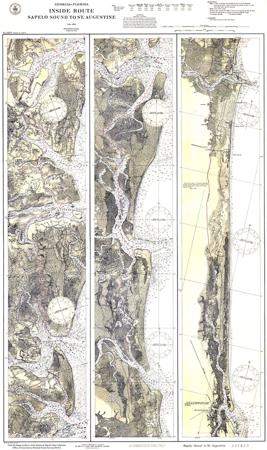
Description: Soundings of the Sapelo Sound to St. Augustine Channel, taken in feet, demonstrates the depth of the river channels for shipping passways. Portrays minimum depth in the inland waterways between St. Johns River and St. Augustine, FL through Pablo Creek. Scale is 1:80000. N.O.A.A. map reference: 3257_12-1925. Key to NOAA maps. PLEASE NOTE: This historical data is not to be used for navigation or navigation planning. The Florida Center for Instructional Technology (FCIT) does not assume responsibility for the improper use of these data.
Place Names: 1920-1949, Saint Augustine
ISO Topic Categories: environment, inlandWaters, transportation
Keywords: Georgia - Florida Inside Route: Sapelo Sound to St.Augustine, physical, transportation, hydrological, political, physical features, local jurisdictions, water routes, water depths, environment, inlandWaters, transportation, Unknown,1924
Source: U.S. Coast and Geodetic Survey, (Washington, DC: U.S. Coast and Geodetic Survey, 1924)
Map Credit: Courtesy of the U.S. National Oceanic and Atmospheric Administration |
|