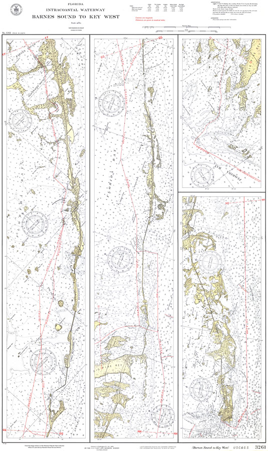
Description: A National Oceanic and Atmospheric Administration map of the Intracoastal Waterway from Barnes Sound to Key West, current to 1932. This National Ocean Survey chart shows all soundings expressed in feet. Courses are given in magnetic degrees; distances are given in nautical miles. Navigational aids such as lights, beacons, buoys and measures of magnetic declination variances are shown as well as obstructions such as shoals, submerged piles, fixed bridges, and overhead cables. The map scale is 1:80,000. N.O.A.A. map reference: 3261_10-1932. Key to NOAA maps. PLEASE NOTE: This historical data is not to be used for navigation or navigation planning. The Florida Center for Instructional Technology (FCIT) does not assume responsibility for the improper use of these data.
Place Names: 1920-1949, Key West, Key Largo, Long Key, Key Vaca, Saddlebunch Keys, Big Pine Key, Boca Chica,
ISO Topic Categories: inlandWaters, oceans, transportation
Keywords: Barnes Sound to Key West, physical, transportation, hydrological, physical features, roads, water routes, water depths, inlandWaters, oceans, transportation, Unknown,1932
Source: National Oceanic and Atmospheric Administration, Intracoastal Waterway (Washington, DC: United States Coast and Geodetic Survey, 1932)
Map Credit: Courtesy the U.S. National Oceanic and Atmospheric Administration |
|