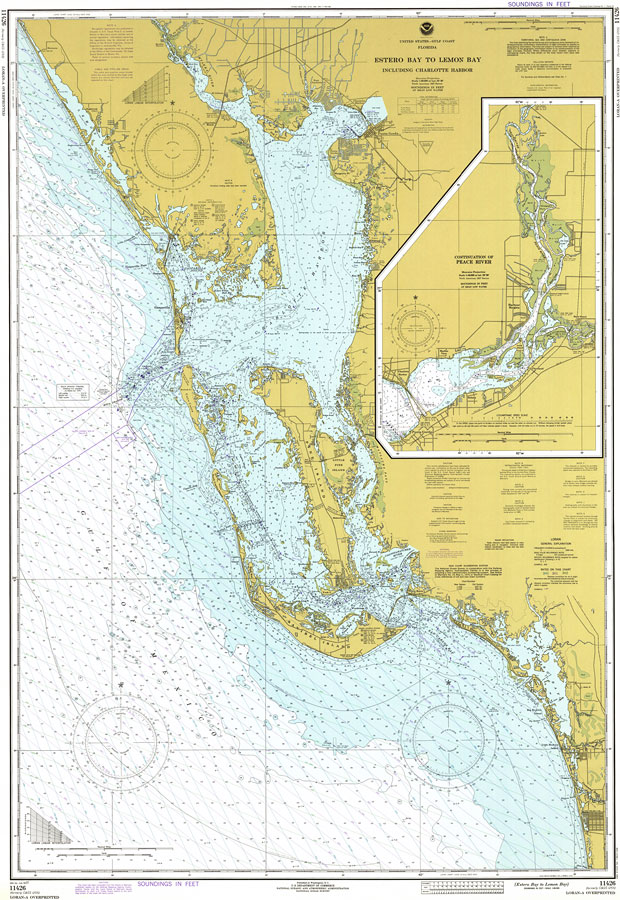
Description: A National Oceanic and Atmospheric Administration map of Gulf Coast from Estero Bay to Lemon Bay, including Charlotte Harbor current to 1977. This Department of Commerce chart shows all soundings expressed in feet at mean lower low water. A detailed map showing the continuation of Peace River is included. Navigational aids such as lights, beacons, buoys and measures of magnetic declination variances are shown as well as obstructions such as shoals, submerged piles, wreckages, fixed bridges and overhead cables. The map scale is 1:80,000. Detailed map scale is 1:40,000. North American Datum of 1927 is used. Key to NOAA maps.
Place Names: 1950-1999, Charlotte Harbor, Punta Gorda, Peace River, Pine Island, Little Pine Island, Estero Island, San Carlos Bay, Estero Bay, Sanibel Island, Gaspasilla Island, Gasparilla Sound,
ISO Topic Categories: inlandWaters, transportation
Keywords: Estero Bay to Lemon Bay, Including Charlotte Harbor, physical, transportation, hydrological, physical features, roads, railroads, water routes, water depths, inlandWaters, transportation, Mercator, 1977
Source: National Oceanic and Atmospheric Administration, United States - Gulf Coast, Florida (Washington, D.C.: U.S. Department of Commerce, 1977)
Map Credit: Courtesy the U.S. National Oceanic and Atmospheric Administration |
|