mapsExploring Florida
 FL Maps > Local > Clay > Revised Plat of the City of Belmore, Clay Co., Florida: situated in sections 12 and section 13 of township 7 South R24 East., 1885 AD
Site Map 

Revised Plat of the City of Belmore, Clay Co., Florida: situated in sections 12 and section 13 of township 7 South R24 East., 1885 AD

Revised Plat of the City of Belmore, Clay Co., Florida: situated in sections 12 and section 13 of township 7 South R24 East.


Title: Revised Plat of the City of Belmore, Clay Co., Florida: situated in sections 12 and section 13 of township 7 South R24 East.
Projection: Unknown
Source Bounding Coordinates:
W: E: N: S:

Main Map Page
Zoomify Version
B/W PDF Version
Color PDF Version
Puzzles: Easy, Medium, Hard
Google Earth
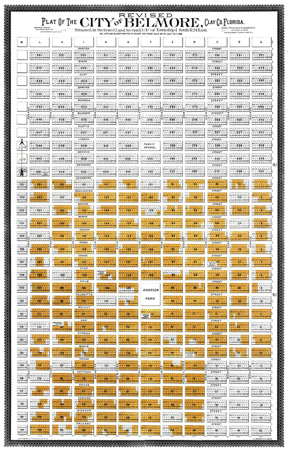
Description: Digitization provided by the USF Libraries Digitization Center. Rare Maps. This is a plat map of the city of Belmore in Clay county, FL circa 1885. Section Township Range (STR) is shown. The map shows the layout of the city and notes lots that are sold "All lots and blocks printed in colors are those sold up to July 15, 1885." Measurements.Dimensions: 49.5 x 78 cm.
Place Names: Clay, Belmore
ISO Topic Categories: transportation, location
Keywords: Revised Plat of the City of Belmore, Clay Co., Florida: situated in sections 12 and section 13 of township 7 South R24 East., historical, transportation, political, local jurisdictions, roads, transportation, location, Unknown,1885 AD
Source: J. J. Trevers, (Belmore, FL: Belmore Florida Land Co., 1885)
Map Credit: Courtesy of the Special Collections Department, University of South Florida.
SearchLicensePDF HelpGIS Help Google Earth Help Zoomify Help

 FL Maps > Local > Clay > Revised Plat of the City of Belmore, Clay Co., Florida: situated in sections 12 and section 13 of township 7 South R24 East., 1885 AD
Site Map