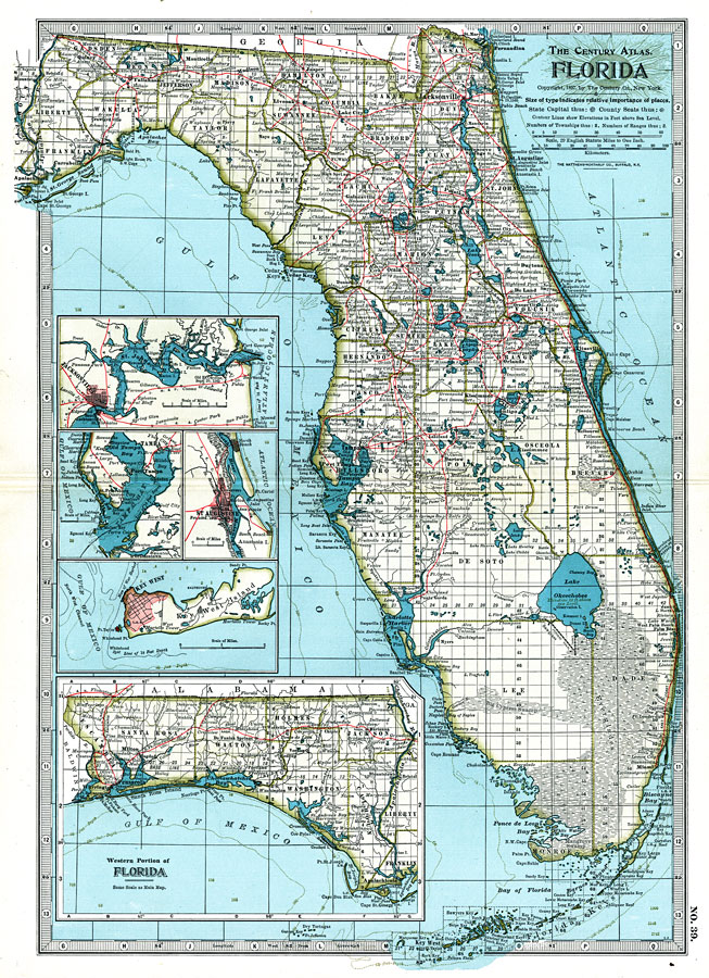
Description: The Century Atlas map of Florida shows county lines current to 1897, including each county seat and major towns. The railroad system extends as far south as Punta Gorda (Charlotte Harbor) on the Gulf Coast, and Miami on the Atlantic Coast. Major rivers and wetlands are shown as well as relatively detailed information of the coastline, the Florida Keys, and barrier islands. Light houses and the House of Refuge sites established by the U.S. Lifesaving Service (precursor to the United States Coast Guard) are shown along the coast. Forts and important battle sites (including dates) are shown. Longitude is shown as west from Greenwich, with the Township and Range grid extending from the Tallahassee Base Line and the Tallahassee Meridian (established in 1824). Elevation contours are only given in 100-foot increments, so there is only one contour line shown on this map. Sounding measurements are given in feet, with an 18-foot, 60-foot, and 100-foot depth contour line shown. The elevation of lake Okeechobee is given as 23 feet above sea level.Existing and proposed drainage canals are shown to the southwest of Lake Okeechobee. The western panhandle (approximately west of the Apalachicola River) is shown on an inset map. Additional inset maps show details of Jacksonville and the St. Johns River, Tampa Bay, St. Augustine, and Key West.
Place Names: 1880-1899, Cape Canaveral, Daytona Beach, Fort Lauderdale, Myers, Fort Myers, Gainesville, Jacksonville, Key West, Miami, Naples, Orlando, Pensacola, Saint Augustine, Sarasota, St Petersburg, Tallahassee, Tampa, West Palm Beach
ISO Topic Categories: boundaries, elevation, inlandWaters, oceans, transportation
Keywords: Florida, physical, political, transportation, hydrological, physical features, topographical, county borders, major political subdivisions, railroads, water depths, boundaries, elevation, inlandWaters, oceans, transportation, Unknown,1897
Source: , The Century Atlas (New York, NY: The Century Co., 1897) 39
Map Credit: Courtesy the private collection of Roy Winkelman. |
|