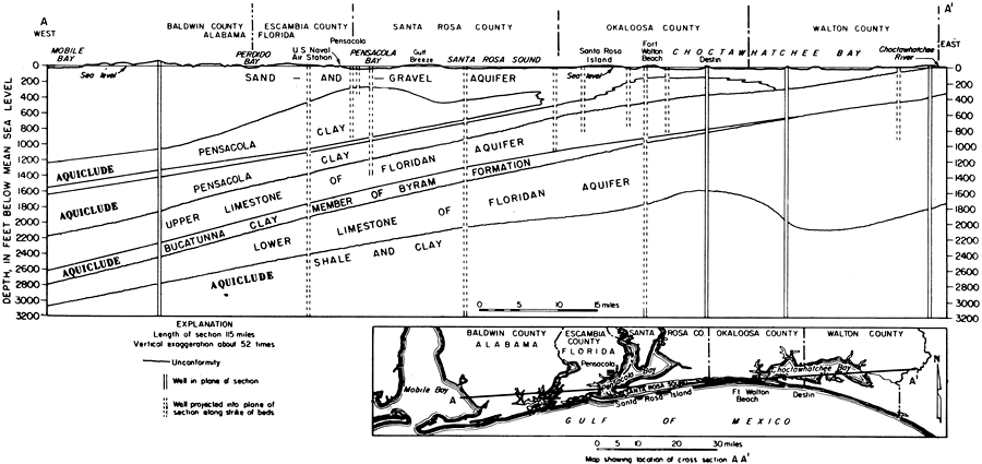
Description: This is a map showing geology along the coast of northwestern Florida showing aquifers and aquicludes, current to 1967. "Most of the wells in Escambia and Santa Rosa Counties draw water from the sand-and-gravel aquifer. This aquifer extends from the surface to depths ranging from 200 feet to 1,000 feet and thickens to the west." — Florida Bureau of Geology Please see the article Ground-Water Features in Escambia and Santa Rosa Counties, Florida by Jack T. Barraclough for more information.
Place Names: 1950-1999, Escambia County, Santa Rosa County, Okaloosa County, Walton County, Pensacola, Gulf of Mexico, Pensacola Bay, Ft. Walton Beach, Destin, Santa Rosa Island
ISO Topic Categories: geoscientificInformation, inlandWaters, boundaries, oceans
Keywords: Ground-Water Features in Escambia and Santa Rosa Counties, Florida- Figure 3, physical, hydrological, political, transportation, geological, county borders, roads, geoscientificInformation, inlandWaters, boundaries, oceans, Unknown,1967
Source: U. S. Geological Survey, Bureau of Geology, Florida Department of Natural Resources, Florida Bureau of Geology (Tallahassee, FL: Florida Bureau of Geology, 1967)
Map Credit: Courtesy the University of South Florida Library |
|