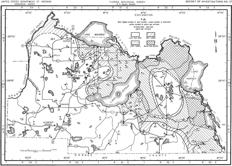
Description: This map shows the dissolved solids content of water from the Floridian aquifer in Seminole County, current to 1962. "The residue of a water, on evaporation, consists of the mineral materials reported in the analyses. A small quantity of organic material or water crystallization is sometimes included. The amount of dissolved solids found in 170 ground-water samples from Seminole County ranged from 80 to 13,900 ppm. Water that has less than 500 ppm of dissolved solids is usually satisfactory for domestic use. Water that has more than 1,000 ppm of dissolved solids is likely to have enough of certain constituents to produce a noticeable taste or make the water undesirable for many uses." — Jack T. Barraclough, U. S. Geological Survey, 1962
Place Names: Seminole, Orange County, Lake County, Volusia County, St. Johns River, Lake Monroe, Lake Jessup, Wekiva River, Econlockhatchee River, Geneva, Lake Harney, Chuluota, Oviedo, Fern Park, Altamonte Springs, Longwood, Sanford, Paola, Lake Mary, counties
ISO Topic Categories: boundaries, geoscientificInformation, transportation, inlandWaters
Keywords: Dissolved Solids, physical, political, transportation, hydrological, geological, county borders, roads, boundaries, geoscientificInformation, transportation, inlandWaters, Unknown,1962
Source: Jack T. Barraclough, U. S. Geological Survey, Ground-Water Resources of Seminole County, Florida (Tallahassee, FL: Florida Geological Survey, 1962)
Map Credit: Courtesy the University of South Florida Library |
|