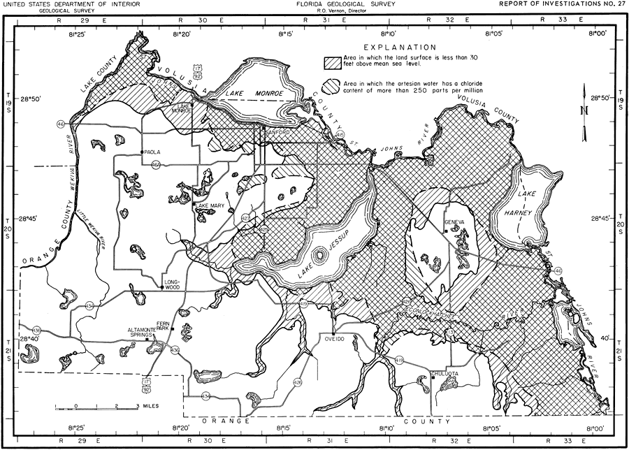
Description: This map shows the relationship of the chloride content of artesian water to the land surface altitude in Seminole County, current to 1962. "Chloride (Cl) is abundant in sea water and is dissolved in small quantities from rocks. The chloride content of ground water is generally a reliable index of contamination by sea water because about 91 percent of the dissolved solids content of sea water consists of chloride salts. The U. S. Public Health Service (1946) recommends that the concentration of chlorides no exceed 250 ppm in water on carriers subject to Federal quarantine regulations." — Jack T. Barraclough, U. S. Geological Survey, 1962 As one could tell by looking at this map, the crosshatch area shows where land surface lower than 30 feet above sea level meets the area in which there is a chloride content of more than 250 ppm (parts per million).
Place Names: Seminole, Orange County, Lake County, Volusia County, St. Johns River, Lake Monroe, Lake Jessup, Wekiva River, Econlockhatchee River, Geneva, Lake Harney, Chuluota, Oviedo, Fern Park, Altamonte Springs, Longwood, Sanford, Paola, Lake Mary, counties
ISO Topic Categories: boundaries, geoscientificInformation, transportation, inlandWaters
Keywords: Chloride Content and Land Surface Altitude, physical, political, transportation, hydrological, geological, county borders, roads, boundaries, geoscientificInformation, transportation, inlandWaters, Unknown,1962
Source: Jack T. Barraclough, U. S. Geological Survey, Ground-Water Resources of Seminole County, Florida (Tallahassee, FL: Florida Geological Survey, 1962)
Map Credit: Courtesy the University of South Florida Library |
|