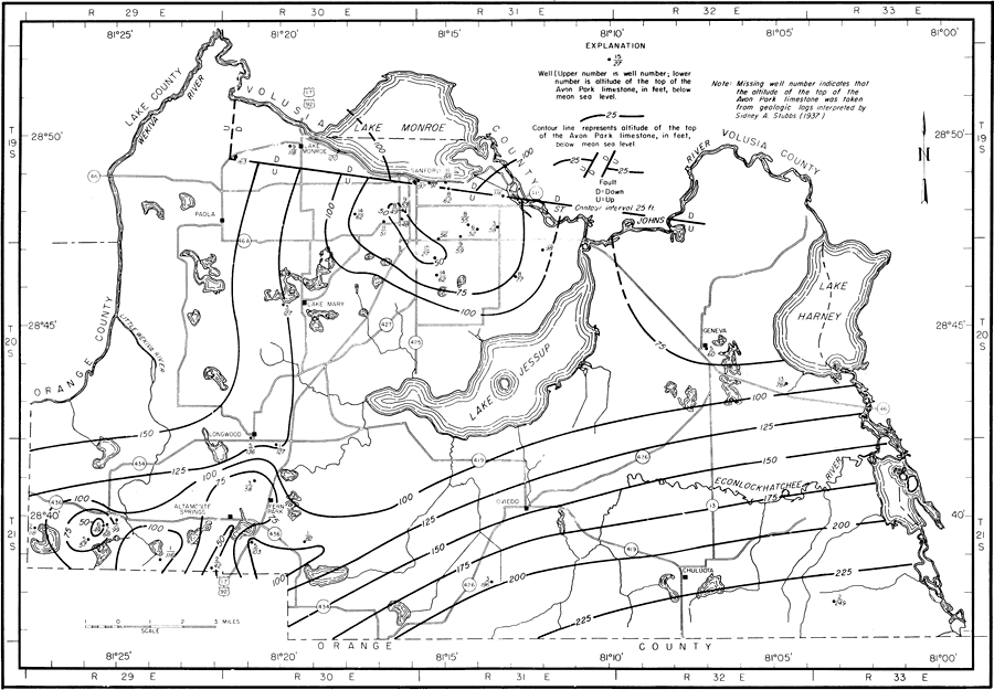
Description: This map shows the configuration and altitude of the top of the Avon Park Limestone in Seminole County, current to 1962. "Structure: Subsurface contours on the top of the Avon Park Limestone are shown in figure 5. This figure shows the top of the Avon Park Limestone to be about 27 to about 100 feet below sea level in the area around Sanford and about 250 feet below sea level in the southeastern part of the county. The eroded surface of the Avon Park Limestone slopes south-southeast about 25 feet per mile in the area from Lake Jessup south and southeast toward Orange County. West of Sanford the surface of the Avon Park slopes west, toward the Wekiva River, about 20 feet to the mile." — Jack T. Barraclough, U. S. Geological Survey, 1962
Place Names: Seminole, Orange County, Lake County, Volusia County, St. Johns River, Lake Monroe, Lake Jessup, Wekiva River, Econlockhatchee River, Geneva, Lake Harney, Chuluota, Oviedo, Fern Park, Altamonte Springs, Longwood, Sanford, Paola, Lake Mary, counties
ISO Topic Categories: boundaries, geoscientificInformation, transportation, inlandWaters
Keywords: Configuration and Altitude of the Top of the Avon Park Limestone, physical, political, transportation, hydrological, geological, county borders, roads, boundaries, geoscientificInformation, transportation, inlandWaters, Unknown,1962
Source: Jack T. Barraclough, U. S. Geological Survey, Ground-Water Resources of Seminole County, Florida (Tallahassee, FL: Florida Geological Survey, 1962)
Map Credit: Courtesy the University of South Florida Library |
|