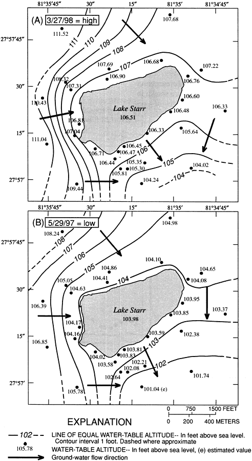
Description: This map from the U. S. Geological Survey Water Resources Investigation Report number 00-4030 shows the water table configurations at Lake Starr during representative high water and low water conditions. Contour lines show equal water table altitude in feet above sea level, with well measurement values showing point water table altitudes. Dark arrows indicate the general direction of groundwater flow. Lake Starr, a 134-acre seepage lake of multiple sinkhole origin on the Lake Wales Ridge of central Florida, is typical of karst terrain lake hydrology in Florida, which is complex in its integral connection between surface and ground water.
Place Names: Polk, Lake Wales
ISO Topic Categories: elevation, geoscientificInformation, inlandWaters
Keywords: Water Table Altitude and Groundwater Flow Direction for Lake Starr, physical, hydrological, khydrological, physical features, geological, currents, water table, elevation, geoscientificInformation, inlandWaters, Unknown,March 1998 and May 1997
Source: Amy Swancar, T. M. Lee, and T. M. O'Hare, USGS Water Resources Investigations Report 00-4030 (Tallahassee, FL: U. S. Geological Survey, 2000) 25
Map Credit: Courtesy the University of South Florida Library |
|