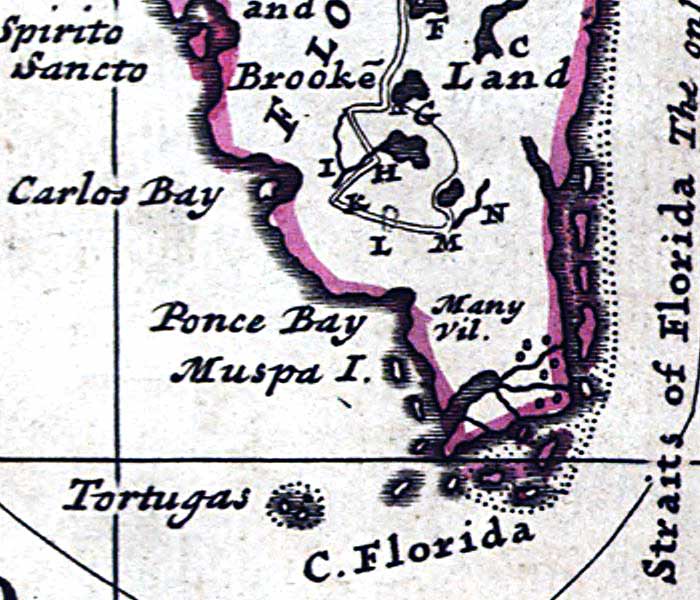
Description: A detail from the 1719 Moll World Map showing the southernmost Florida peninsula, coastline, the Straits of Florida, Ponce Bay (Ponce De Leon Bay), Carlos Bay (Charlotte Harbor), The Tortugas (Dry Tortugas, Cape Florida (Cape Sable), and village locations of the Muspa Indians. The partial route of a slave-hunting expedition from the St. Whan's River (St. Johns) to the interior is shown and described as: "Explanation of an Expedition in Florida neck, by Thirty-three Iamesee Indians Accompany’d bt Capt. T. Nairn. A. The place where the Indians leave their Canoes to go a Slave-Hunting, it is 6 days Rowing from St. Whan’s Rivers Mouth. B. Large inland Lakes, some of them joined together. C. The Furthermost place where ye Indians have gone with Canoes. D. Place where they left their Canoes. E. The Path they took to go a Slave Catching. F. Cacema Town. G. Large Pond where was one house. H. Place where they Swam over a Deep River. I. The same River is here Brackish. K. Place where they took 29 Slaves. L. Here they took 6 Slaves. M. Here they took and Killed 33 Men at 2 a Clock ye same day a very Numerous body of Indians came against them, they being but 33 Men, yet put them presently to Flight; they having no Armes but Harpoos, made of Iron and Fish bones; they were all Painted. N. Fresh water Creek."
Place Names: 1700-1719, Florida, Brooke Land, Ponce Bay, Ponce De Leon Bay, Tortugas, Carlos Bay, Charlotte Harbor,
ISO Topic Categories: inlandWaters, oceans, society
Keywords: Detail - A new map of the north parts of America claimed by France..., physical, political, historical, physical features, major political subdivisions, inlandWaters, oceans, society, Mercator, 1719
Source: Herman Moll, (London, : John Bowles, 1720)
Map Credit: Courtesy of the Geography and Map Division of the Library of Congress |
|