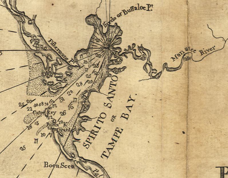
Description: This detail of Tampa Bay is from a map drawn in 1774, part of a two map set showing the southern peninsula of Florida with neighboring islands and waters. It is primarily a navigational chart with rhumblines, soundings, and coastal features. The map includes sailing directions, notes on some shipwrecks, and 9 land identification profiles. Relief shown by hachures. Depths shown by soundings. This detail shows the Tampe Bay, or Tampa Bay area, with references to Fishermans Point in Pinellas, Sivclo or Buffaloe Point near what today is known as Tampa, and falls along the Manatee River. Today's Egmont Key is labeled Castor Key, and Passage Key is called Pollux Key.
Place Names: 1760-1779, Tampe Bay, Spirito Santo Bay, Tampa Bay, Fishermans Point, Pinellas Point, Buffaloe Point, Manatee River, Castor Key, Egmont Key, Boca Soca
ISO Topic Categories: inlandWaters, oceans, society, transportation
Keywords: Detail - Florida and its vicinity, physical, historical, transportation, physical features, water routes, inlandWaters, oceans, society, transportation, Unknown,1774
Source: Bernard Romans, A concise natural history of East and West Florida (New York, NY: Peter Force, 1781)
Map Credit: Courtesy of the Geography and Map Division of the Library of Congress |
|