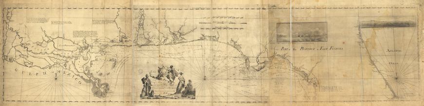
Description: This map drawn in 1774 is part of a two map set showing the northern portion of the Florida peninsula and the Gulf Coast from approximately north of Cedar Keys to the Mississippi River. It is primarily a navigational chart with rhumblines, soundings, and coastal features. The map includes sailing directions, notes on some shipwrecks, and two drawings showing "View of the entrance of St. Mary's River," and "View of Fort St. Marks, at Apalache seen from th[e so]uthward ... " Relief is shown by hachures. Depths shown by soundings. There are interesting notations such as along the Big Bend area of the Gulf Coast: "This Coast is Scarcely to be approached Even in a Canoe, and it must Blow very hard before the Water begins to be too Rough for a Small Maser, no Beach is to be seen excepting at two Cedar Keys marked a & b thus they may be Easily known their Beach is very White, at c is Good Watering at Low Water, & d is a Gravel Bank."
Place Names: 1760-1779, St. Marys River, Saint Augustine, Fort Matanzas, Musketo Inlet, Mosquito Inlet, St. Marks, Fort St. Marks, St. Andrew Bay, Santa Rosa Bay, Pensacola
ISO Topic Categories: inlandWaters, oceans, society, transportation
Keywords: East and West Florida, physical, historical, transportation, physical features, water routes, inlandWaters, oceans, society, transportation, Unknown,1774
Source: Bernard Romans, A concise natural history of East and West Florida (New York, NY: Peter Force, 1781)
Map Credit: Courtesy of the Geography and Map Division of the Library of Congress |
|