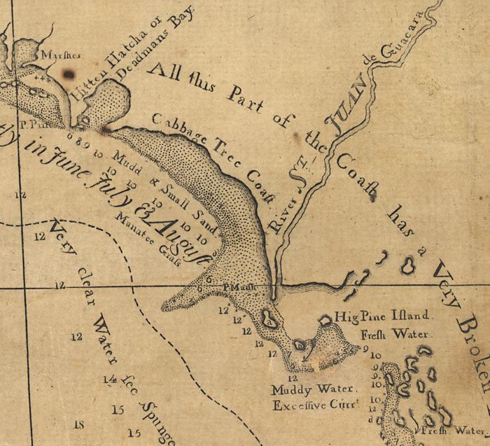
Description: This detail of the Cabbage Tree Coast is from a map drawn in 1774, part of a two map set showing the northern portion of the Florida peninsula and the Gulf Coast from approximately north of Cedar Keys to the Mississippi River. It is primarily a navigational chart with rhumblines, soundings, and coastal features. The map includes sailing directions. Relief is shown by hachures. Depths shown by soundings. This detail shows water depths, offshore sediment composition, and sources for fresh water. Interesting map notations include: "Very Strong Westerly Winds prevail here constantly in June, July, & August""All this Part of the Coast has a Very Broken Appearance" and "Very clear Water see Spunges, small Coral & Grasses on a Sandy Bottom." The Steinahatchee River is shown as the River St. Juan de Guacara.
Place Names: 1760-1779, Deadmans Bay, Hitten Hatcha Bay, Deadman Bay, High Pine Island, River St. Juan de Guacara, Steinahatchee River,
ISO Topic Categories: inlandWaters, oceans, society, transportation
Keywords: Detail - East and West Florida, physical, historical, transportation, physical features, water routes, inlandWaters, oceans, society, transportation, Unknown,1774
Source: Bernard Romans, A concise natural history of East and West Florida (New York, NY: Peter Force, 1781)
Map Credit: Courtesy of the Geography and Map Division of the Library of Congress |
|