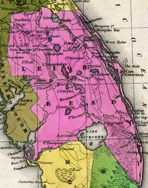
Description: This detail of a map from the Tanner's Universal Atlas shows towns, forts, roads, canals, major rivers and lakes in Mosquito County. Mosquito County is shown as Leigh Read County on this map, a name change that was proposed by the State Legislature, but was never officially adopted. This tract of land is the largest section of Florida at this time. The main lakes on the area are Lake George, Lake Ahapopka, and Lake Okeechobee. Indian River and Kissimmee River traverse the county. There are references to forts, battlefields, and routes used by the Army during the Seminole War. The Longitude is from the Washington Prime Meridian.
Place Names: Leigh Read , Leigh Read, Lake George, Volusia, Lake Ahapopka, Apopka, Mosquito Bar, Mosquito Lagoon, Fort Dade, Fort King, Paynes Lake, Hillsboro River, Hillsborough River, Cape Cannaveral, Cape Canaveral, Indian River, Lake Tohopekaliga, Fort Gardener, Cypress Lake, Lake Poinsett, Kissimmee Lake, Kissimmee, Fort Center, Fort Thompson, Fort Basinger, Lake Okeechobee, Fort Jupiter, Rocky Spring, Charlotte Harbor, New Smyrna,
ISO Topic Categories: boundaries, inlandWaters, oceans, society, transportation
Keywords: Detail- Leigh Read County, physical, political, transportation, historical, physical features, county borders, roads, other military, boundaries, inlandWaters, oceans, society, transportation, Unknown,1839
Source: Henry Schenck Tanner, Tanner's Universal Atlas (Philadelphia, PA: Carey & Hart, 1839) 21
Map Credit: Courtesy the private collection of Roy Winkelman |
|