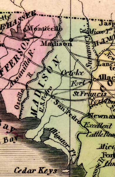
Description: This detail of a 1842 map of Florida shows roads, railroads, counties, forts, naval depots and other military installations, major towns, rivers, and lakes for Madison County. This detail's county is wedged between two rivers, Oscilla and Suwannee, respective to the west and east. The other point of interest is Alligator Point, at the southern tip of the county. Longitude is shown from Greenwich at the top of the map, and Washington at the bottom of the map. The map scale is in &quoe;American Miles."
Place Names: Madison, Madison, Suwannee River, Cetoke, San Pedro, Alligator Point, Santa Fe Bay, Oscilla River,
ISO Topic Categories: boundaries, inlandWaters, oceans, society
Keywords: Detail - Map of the State of Florida, physical, political, transportation, historical, physical features, major political subdivisions, county borders, roads, boundaries, inlandWaters, oceans, society, Unknown,1842
Source: Jeremiah Greenleaf, A New Universal Atlas (Brattleboro, VT: , 1842) 56
Map Credit: Courtesy the private collection of Roy Winkelman |
|