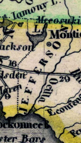
Description: Meyer's 1845 map of Florida is derived from the Tanner/Mitchell Universal atlas map of 1839. This detail of that map covers Jefferson County. Routes of travel are covered along with major waterways. The southern border is lined by the Ocklockonee Bay. Lake Miccosukee, then called Mecosukie Lake, is along the northern edge of Jefferson County.
Place Names: Jefferson, Monticello, Ocilla, Mecosukie Lake, Ocklkockonee Bay, Lake Miccosukee, Aucilla
ISO Topic Categories: boundaries, inlandWaters, oceans, society, transportation
Keywords: Jefferson County, physical, political, transportation, historical, physical features, major political subdivisions, roads, boundaries, inlandWaters, oceans, society, transportation, Unknown,1845
Source: Joseph Meyer, Grosser Hand-Atlas uber alle Theile der Erde (Hillsburghaus, : Hildburghausen: Bibliographischen Instituts, 1845) 148
Map Credit: Courtesy the private collection of Roy Winkelman |
|