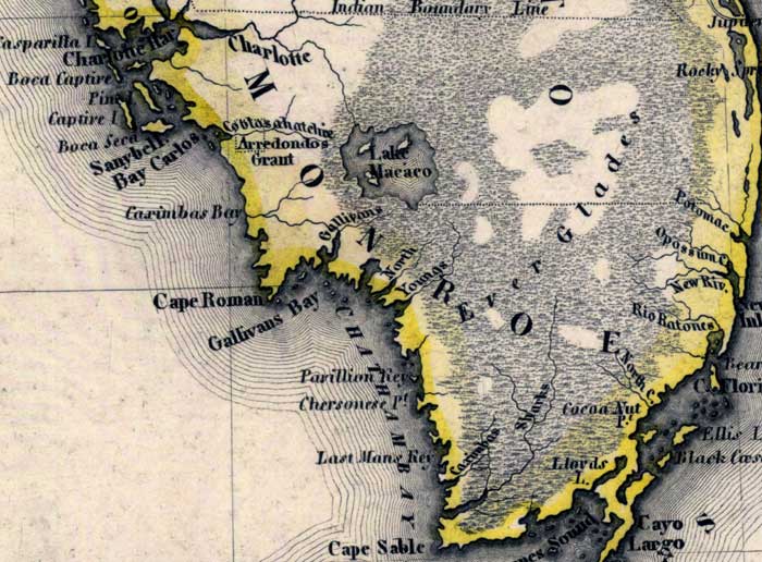
Description: Meyer's 1845 map of Florida is derived from the Tanner/Mitchell Universal atlas map of 1839. This detail of that map covers the mainland of Monroe County. Routes of travel are covered along with major waterways. The Everglades expand over the majority of the detail. Most labels are of coastal features, such as Charlotte Harbor, Cape Romano, and Gallivans Bay.
Place Names: Monroe, Everglades, Lake Macaco, Boca Captive, Pine Island, Boca Seca, Sanybell, Bay Carlos, Caximbas Bay, Cape Roman, Cape Romano, Gallivans Bay, North River, Youngs River, Pavillon Kay, Chersonese Point, Last Mans Key, Caximbas River, Sharks River, Cape Sable, Lloyds Lake, Cocoa Nut Point, Barnes Sound, Black Caesar Creek, Rio Ratones, New Inlet, Ellis Island, Opossum Creek, Potomac, Rocky Spring, Jupiter Inlet, Key Largo
ISO Topic Categories: boundaries, inlandWaters, oceans, society, transportation
Keywords: Monroe County - Mainland, physical, political, transportation, historical, physical features, major political subdivisions, roads, boundaries, inlandWaters, oceans, society, transportation, Unknown,1845
Source: Joseph Meyer, Grosser Hand-Atlas uber alle Theile der Erde (Hillsburghaus, : Hildburghausen: Bibliographischen Instituts, 1845) 148
Map Credit: Courtesy the private collection of Roy Winkelman |
|