| Home > Floripedia > St. Augustine: Fort Marion | |
Description of Fort Marion
St. Augustine Under Three Flags: Tourist Guide and History1918
After John Davis' raid in 1665, the plans of the castle were changed and the work of reconstruction begun. Spanish governors and soldiers came and went and still the work went on. It was not until 1756, ninety-one years later, that the work, as we see it today, was finished and the engineer in charge could place over the entrance the coat of arms of Spain with inscription, which, translated, reads:
Don Fernandez the Sixth being King of Spain, and Field Marshal Don Alonzo Fernandez de Herreda, Governor and Captain-General of the city of St. Augustine, Florida, and its province, this fortress was finished in the year 1756. The works were directed by the Captain-Engineer, Don Pedro de Brazas y Garay.
During all the Spanish rule the structure was known as San Marco Castle. After coming into possession of the United States the name was changed to Fort Marion, in honor of General Francis Marion of Revolutionary fame.
Built of Coquina—The fort is built of coquina (a shell rock of natural formation, found only on the eastern coast of Florida), which was obtained from quarries two miles below the present light house, on what is known as the old quarry road. These quarries will richly repay a visit. The blocks of cut stone were carried on cross-bars, resting on the shoulders of slaves, over a long causeway (still in an excellent state of preservation) to a landing on Quarry Creek. Here they were loaded on barges and transported down the creek and across the bay to the Castle, where they were again carried and placed in their present position.
Notwithstanding the fact that most of the work was done by slaves, we are told that upwards of thirty million dollars were expended on the work, and the King of Spain, on learning this, exclaimed, "Its curtains and bastions must be made of solid silver."
Bastions and Towers—The fort has nearly equal bastions (the triangular-shaped corners), known as St. Peter, St. Paul, St. Augustine and St. Charles, and four connecting walls called curtains. On three of the bastions are sentry towers, while on that to the northeast stands a high watch tower, commanding a view of both land and water. The walls are about 12 feet thick at the base, 9 feet at the top, and about 25 feet high.
Plaza, Ramp, and Terreplein—The plaza, or inner court, is 100 feet square, and the casemates, with one or two exceptions, open into it. There are 26 casemates, five dungeons and one magazine. The only entrance is through the sallyport in the middle of the south curtain.
The covering over the space between the inner and outer walls is called the terreplein, and is about 40 feet wide. Upon it the guns were mounted. Around the outer edge of the terreplein is a wall 3 feet thick and 6 feet high, known as the parapet. This was pierced for 64 guns. On the water front the parapet was lower.
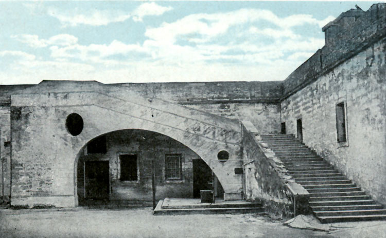
The ascent to the terreplein is up an incline plane known as the ramp, recently converted into steps. The upper part of the ramp is supported by a peculiar shaped arch, remarkable for the fact that it was constructed without a keystone.
THE RAMP, FORT MARION
Incline used by Spaniards for transporting cannon from plaza to terreplein, steps being modern. Arch of great strength, without a keystone.Casemates—the two casemates at the right of the entrance were guard rooms, and contain fireplaces. Leading off from the inner of these rooms is a large dungeon which was used as the general prison.
The casemate at the left of the entrance was the commander's quarters, while the two rooms leading off from it were used by the other officers of his staff.
Court Room &ndash (Osceola)—In the southwest corner of the court is the court room, where the raised platform for the officers of the court may still be seen. In this room in 1837 the famous Indian chief, Osceola, together with Coacoochee and Talmus Hadjo, were imprisoned. At the rear of the room are the niches which the two latter dug in the masonry to enable them to climb to the ventilator, through which they made their escape.
Council Chamber and Powder Magazine—In the northwest corner of the court is the room used as the council chamber. Leading from this is a dungeon, which was used as the powder magazine. At one side near the top of the magazine is a large niche with a small opening looking into the council room, but not visible from that side. It is supposed that this was so arranged in order that the Commandant could listen to the proceedings of the council without their knowledge.
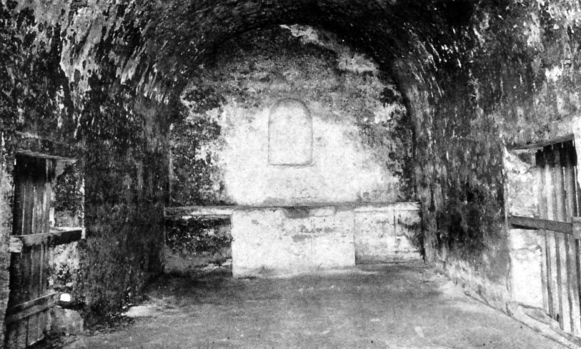
Chapel—At the north side of the court, directly opposite the sallyport, is the chapel. The entrance to this room was very ornamental. This work, which had become nearly obliterated by the action of the elements, has recently been reconstructed by the War Department, great care being taken in following the original plans, which were obtained from the Spanish Government. Entering, we see on each side the niches for holy water; just beyond, on the right, pieces of cedar imbedded in the masonry mark the place where the confessional was fastened to the wall. At the rear is a raised stone platform for the altar, and above the altar a large niche where stood the patron saint, Saint Augustine. Looking up, we see near the spring of the arch the ends of the old timbers which supported the platform for the choir. Directly overhead, near the middle of the room, is a square hole from which hung an immense wooden cross called the rood. On either side of the chapel are doorways through the iron bars of which the prisoners could hear mass before being executed. The bars were necessary, as if a prisoner gained access to a chapel and knelt at the altar, he could claim the right of sanctuary.
CHAPEL, FORT MARION
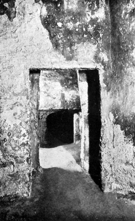
Showing niche for the patron saint St. Augustine and the altar. Also doors at sides through bars of which prosoners were allowed to hear mass before being executed. The brightest and most patriotic Spanish clergy have celebrated mass in this room.Secret Dungeons—At the northeast corner of the court is a room called "Pennancarrah." On the south wall of this room can be seen the marks where six crosses were fastened to the wall. Under these crosses prisoners were suspended in chains in such a manner that they could neither sit or lie down. In this room were also several shrines. At the north side of this room we enter a dungeon, 30 feet long on the west side, 16 feet on the east, 17 feet on the south and 20 feet on the north. This we are told was a prison. Through an opening at the north side of this room we enter a room 5 feet wide at the east end, 7 feet at the west, 20 feet long and 15 feet high. This room was used as a torture chamber. Several feet above the floor are the holes where rotting timbers of a rack were found. The rack was a frame on which a man was fastened so that when the frame was stretched by means of levers the man's joints could be separated. If carried to the extreme he would be torn limb from limb. From this room we find a small opening 36 inches wide by 30 inches high. This opening had been carefully walled up in such a manner as to almost baffle discovery, but was found by Lieutenant Tuttle and Colonel Dancy in 1833.
Passing through this opening we enter a dungeon 20 feet long, 13 feet wide and about 7 feet high. In this dismal place, where not the faintest ray of daylight ever penetrates, and far from the sounds of the outside world, were found crumbled human bones. The finding of these bones was reported to the War Department by Lieutenant Tuttle on July 21, 1833. A copy of this report is now in the possession of the St. Augustine Historical Society. In one corner of this room is the outline of a hole called the oublette, which, tradition tells us, extended down to quicksand and was used for the disposal of the dead. A visit to these rooms, which were accidentally discovered in 1833, should convince the most skeptical of the cruelty of those early days.IN THE DUNGEONS, FORT MARION
Showing entrance to famous secret dungeon through an aperture 30 inches in height by 3 feet wide. The most interesting part of the old fort.THE FAMOUS SECRET DUNGEON, FORT MARION
This dungeon in the northeast bastion was accidentally discovered in 1833. In it were found crumbled human bones.Moat—Around the fort is a moat 40 feet wide, which is now filled in to the depth of about 6 feet with sand. Protecting the entrance is the barbacan, which the water of the moat formed into an island, access being gained to the barbacan and thence to the fort by means of drawbridges. Inside the drawbridge was the portcullis, which ran in a groove still to be seen. Directly above the portcullis may still be seen a hole, some five or six inches in diameter, through which melted lead could be pored upon the heads of invaders, should they succeed in crossing the drawbridge, which, however, they never did.
Outside the moat on three sides is the covered way, a narrow level space for the massing of troops, which widen in spots, called places of arms. Outside of all, except on the water front, is the glacis, and earthen embankment leading up to the fort and so constructed that the guns on the walls could sweep every foot of it.
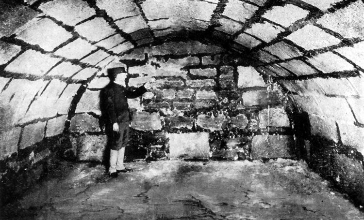
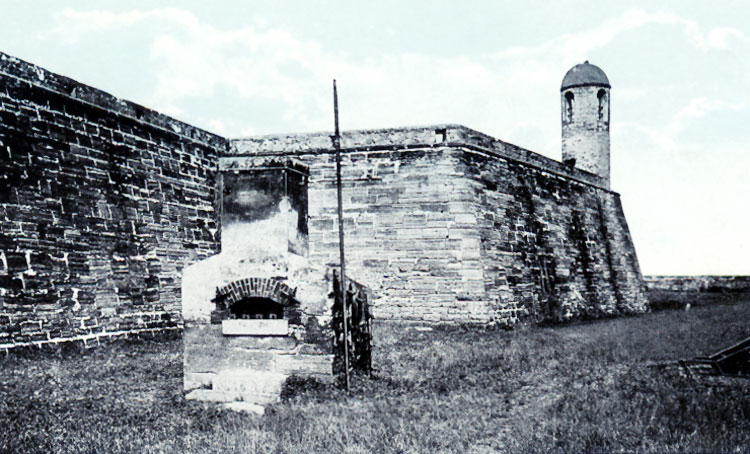
Hot Shot Oven—The hot shot oven and water battery were constructed by the United States Government in 1835–42, the object being to head shot white hot in the oven and fire them from the mortars at the vessels of an approaching enemy. The present sea wall was constructed at this time at an expense of one hundred thousand dollars.
In the walls of the fort, both front and back of the hot shot oven, can be seen the bullet holes where prisoners were executed.
HOT SHOT OVEN, FORT MARION
In this oven shot were heated to fire at wooden vessels. At the rear may be seen bullet holes in a wall where prisoners were executed.Fort Marion is in all respects a castle built after the plan of those of the middle ages, and is today one of the best preserved specimens of the military architecture of its time. It was withstood many sieges and proven itself capable on all occasions of resisting the enemy. Its casemates and dungeons are viewed with wonder and amazement by more than one hundred thousand visitors annually.
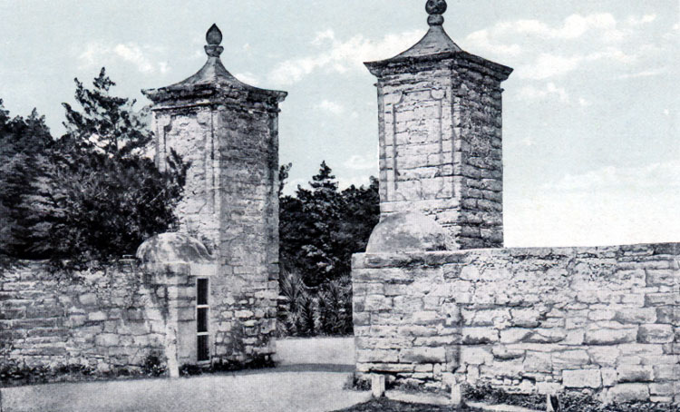
City Gates and Early Defenses of St. Augustine 1702–27—St. Augustine being surrounded by water on three sides, there was little danger of an attack except from the north. To guard against this, three lines of defense were constructed across the peninsula from the Matanzas to the San Sebastian rivers. Fort Moosa was located on the Matanzas river about two and a half miles north of the present post office. This fort was of considerable size. It was a complete fortress with four bastions, moat, drawbridge, etc., and garrisoned at one time with 133 men. A line of defense extended across the peninsula near what is now Myrtle Avenue. The inner and last line ran from Fort Marion to the San Sebastian, and the present City Gates were then the only entrance to the city. The gates, as we see them today, were built of stone, but the rest of the wall was logs stood on end. On the outer side of this wall was a moat, or deep ditch (a section of this may still be seen near the San Sebastian) filled with water, and the approach to the gates was over a drawbridge which was pulled up at night. An additional line of defense, consisting of a breastworks of earth, having on its summit several rows of Spanish bayonets, planted so closely as to be almost impenetrable, extended from the northern wall south on what is now the line of Cordova Street to a point almost abreast the barracks, from where it ran east and joined the Matanzas.
OLD CITY GATES
Built in 1702–27: consisting of two square pillars of coquina rock. 20 ft. in height, 10 ft. thick. Walls are about 30 ft. in length and 10 ft. thick. Space between pillars is 12 ft and was protected with heavy iron bound gates. The approach was by way of a draw-bridge over the moat, or ditch.Source:
Excerpt from "St. Augustine Under Three Flags: Tourist Guide and History" W. J. Harris Company, 1918, pp. 17–21.
![[back]](https://fcit.usf.edu/florida/i/backbttn.gif)
| Home > Floripedia > St. Augustine: Fort Marion |
Exploring
Florida: A Social Studies Resource for Students and Teachers
Produced by the Florida Center for Instructional
Technology,
College of Education, University of South Florida © 2005.