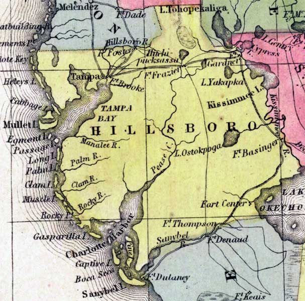
Description: This detail of a 1850 map from the New Universal Atlas shows towns, forts, roads, canals, major rivers and lakes in Hillsborough County. The map is very similar to the 1839 map from Tanner's Universal Atlas. There are references to forts, battlefields, and routes used by the Army during the Seminole War. This detail extends from north of Tampa Bay to south of Charlotte Harbor and as far west as Kissimmee Lake.
Place Names: Hillsborough, Ancloe Key, Heleys Island, Cabbage Island, Mullet Island, Egmont Island, Long Island, Clam Island, Muscle Island, Rocky Point, Gasparilla Island, Charlotte Harbor, Captive Island, Boca Seca, Sanybel Island, Fort Thompson, Fort Center, Fort Basinger, Lake Ostokpoga, Pease Creek, Rocky River, Clam River, Palm River, Palm Island, Manatee River, Tampa Bay, Fort Brooke, Tampa, Fort Foster, Fort Frazier, Fort Gardner, Lake Yakapka, Kissimmee Lake, Lake Tohopekaliga, Lake Okeechobee, Kissimmee River,
ISO Topic Categories: boundaries, inlandWaters, oceans, society, transportation
Keywords: Hillsborough County, physical, political, transportation, historical, physical features, county borders, roads, other military, boundaries, inlandWaters, oceans, society, transportation, Unknown,1850
Source: Samuel Augustus Mitchell, A New Universal Atlas (Philadelphia, PA: Thomas, Cowperthwait & Co., 1850) 21
Map Credit: Courtesy the private collection of Roy Winkelman |
|