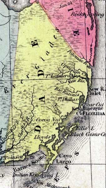
Description: This detail of a 1850 map from the New Universal Atlas shows towns, forts, roads, canals, major rivers and lakes in Dade County. The map is very similar to the 1839 map from Tanner's Universal Atlas. There are references to forts, battlefields, and routes used by the Army during the Seminole War. Many coastal features are pictured, such as Barnes Sound, Cayo Largo, Cape Florida, and New River Inlet.
Place Names: Dade, Potomac River, Opossum River, Fort Lauderdale, New River, Rio Ratones, Fort Dallas, North Creek, Cocoa Nut Point, Lloyds Lake, Sharks River, Fort Poinsett, Caximbas River, Barnes Sound, New Matacomb, Long Island, Cayo Largo, Key Largo, Ellis Island, Black Caesar Creek, Cape Florida, Key Biscayne, Bear Cut, New River Inlet, Everglades, Ft Dallas, Ft Poinsett, Ft. Lauderdale
ISO Topic Categories: boundaries, inlandWaters, oceans, society, transportation
Keywords: Dade County, physical, political, transportation, historical, physical features, county borders, roads, other military, boundaries, inlandWaters, oceans, society, transportation, Unknown,1850
Source: Samuel Augustus Mitchell, A New Universal Atlas (Philadelphia, PA: Thomas, Cowperthwait & Co., 1850) 21
Map Credit: Courtesy the private collection of Roy Winkelman |
|