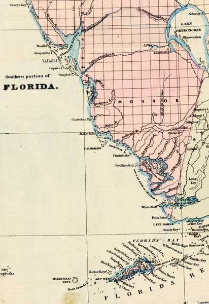
Description: This 1871 detail of Florida shows county lines and county seats current to the period, major towns and cities, and railroad routes and stations for Monroe County. The major water features of this detail are Gallivans Bay and Chatham Bay. Other locations include Cape Romano and Key West. Digitization provided by the USF Libraries Digitization Center.
Place Names: Monroe, La Costa Island, Captive Island, Sanybel Island, Caximbas Bay, Corkscrew River, Malco River, Malco Inlet, Gallivans River, Gallivans Bay, Cape Romano, Pavillion Key, Chatham Bay, Ten Thousand Islands, White Bluff, Palm Point, Marquesas Keys, Key West, Barnes Sound,
ISO Topic Categories: boundaries, inlandWaters, oceans, transportation
Keywords: Monroe County, physical, political, transportation, physical features, major political subdivisions, county borders, railroads, boundaries, inlandWaters, oceans, transportation, Unknown,1871
Source: Asher & Adams, Asher & Adams' new commercial, topographical, and statistical atlas and gazetteer of the United States (New York, NY: Asher & Adams, 1871)
Map Credit: Courtesy of the private collection of Roy Winkelman |
|