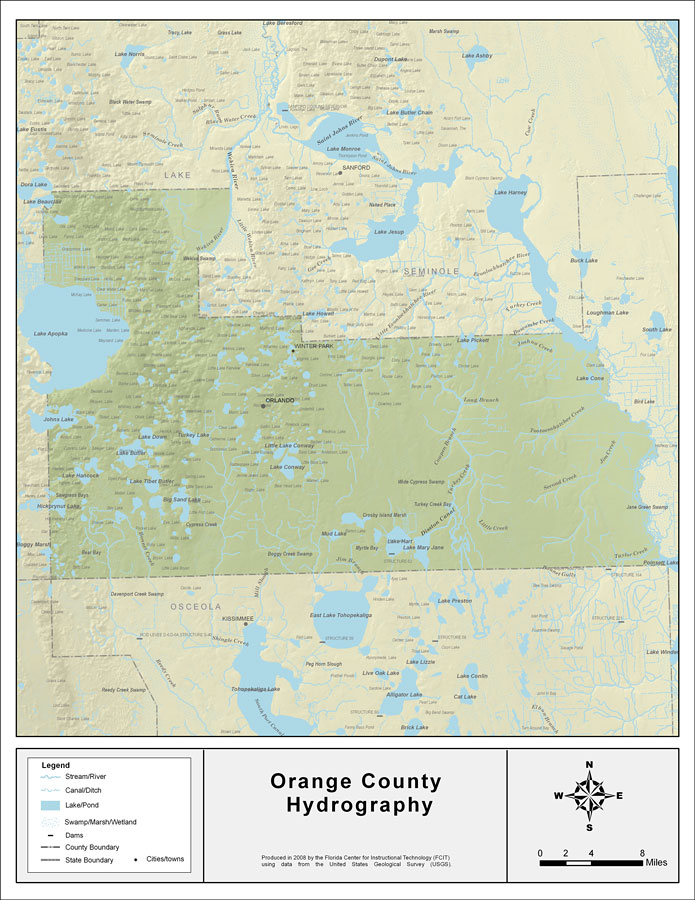
Description: This map was created by FCIT and shows the waterways of Orange County. All major rivers, streams, creeks, lakes, and swamps are labeled. This map features Econlockhatchee River, Lake Pickett, Buscombe Creek, Joshua Creek, Saint Johns River, Lake Cone, Long Branch, Hart Branch, Tootoosahatchee Creek, Cowpen Branch, Green Branch, Turckey Creek, Second Creek, Jim Creek, Disston Canal, Little Creek, Lake Mary Jane, Lake Hart, Mud Lake, Jim Branch, Taylor Creek, Poinsett Lake, Lake Conway, Little Lake Conway, Single Creek, Bonnet Creek, Reedy Creek, Hickorynut Lake, Big Sand Lake, Lake Tibet Butler, Lake Hancock, Lake Butler, Lake Down, Turkey Lake, Jonhs Lake, Lake Apopka, Wekiva River, and Lake Beauclair.
Place Names: Orange, Econlockhatchee River, Lake Pickett, Buscombe Creek, Joshua Creek, Saint Johns River, Lake Cone, Long Branch, Hart Branch, Tootoosahatchee Creek, Cowpen Branch, Green Branch, Turckey Creek, Second Creek, Jim Creek, Disston Canal, Little Creek, Lake Mary Jane, Lake Hart, Mud Lake, Jim Branch, Taylor Creek, Poinsett Lake, Lake Conway, Little Lake Conway, Single Creek, Bonnet Creek, Reedy Creek, Hickorynut Lake, Big Sand Lake, Lake Tibet Butler, Lake Hancock, Lake Butler, Lake Down, Turkey Lake, Jonhs Lake, Lake Apopka, Wekiva River, Lake Beauclair, Orlando, Olympia Lake, Shadow Lake, Killarney Lake, Silvler Lake, Roger Lake, Starke Lake, Speer Lake, Huckleberry Lake, Mabel Lake
ISO Topic Categories: boundaries, inlandWaters
Keywords: Florida Waterways: Orange County , political, physical, kriversandstreams, physical features, county borders, photograph in shape of map, photo, Florida mapboundaries, inlandWaters, 2008
Source: Florida Center for Instructional Technology, (Tampa, FL: University of South Florida, 2008)
Map Credit: Courtesy of the Florida Center for Instructional Technology |
|
