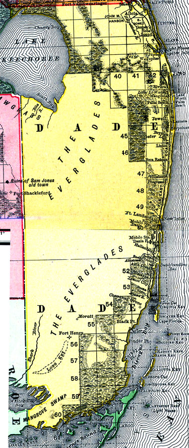
Description: Digitization provided by the USF Libraries Digitization Center. Rare Maps. This is a detail map of Dade county circa 1898. This map shows section township range (STR) except for in the Everglades since that area had not been surveyed yet. Main cities and towns are shown such as the county seat Juno. Inland waters are also shown such as Lake Okeechobee. Scale: Statute Miles, 19 = 1 inch. Engraved, printed and published by Rand, McNally & Company.
Place Names: Dade, Alicia, Stuart, Gomez, Jupiter, Juno, Jupiter Inlet, Riviera, Lake Worth, Palm Beach, Mangonia, Jewell, Boynton, Linton, Lake Okeechobee, Everglades, Boca Raton, Boca Ratone, Hillsboro, Progresso, Ft. Lauderdale, Atlantic Ocean, Hallandale, Biscayne, Key Biscayne, Cutler, Miami, Fort Henry, Moratt, Lemon City, Buena Vista, Cocoanut Grove
ISO Topic Categories: inlandWaters, boundaries, transportation, oceans
Keywords: Dade County, physical, historical, political, transportation, physical features, county borders, railroads, inlandWaters, boundaries, transportation, oceans, Unknown,1898 AD
Source: Rand, McNally and Company, Rand, McNally and Company's Indexed atlas of the world. Florida. (Chicago, IL: Rand, McNally and Company, 1898) 311
Map Credit: Courtesy of the Special Collections Department, University of South Florida. |
|